Plenty of swell for both coasts, cleanest down South

South Australian Surf Forecast by Craig Brokensha (issued Monday June 14th)
Best Days: Tomorrow afternoon South Coast, Wednesday South Coast, early Thursday for the keen South Coast, Friday afternoon for the desperate on the Mid Coast, Saturday morning South Coast, Sunday onwards South Coast
Features of the Forecast (tl;dr)
- Inconsistent W/SW groundswell building late tomorrow, peaking Wed AM with moderate NE tending N/NW winds as it builds, strengthening N/NW tending NW and then W/NW Wed
- Mid-period W'ly swell for Wed PM and Thu AM with fresh W/SW winds, strengthening through the day Thu
- Mod-large SW groundswell Fri but with strong S/SW tending S winds, easing Sat with more variable winds
- Reinforcing W/SW groundswell Sun PM with N/NE tending variable winds
Recap
Clean conditions and a fun, small swell Saturday morning down South, best suited to the swell magnets, tiny yesterday and only for the desperate. The Mid was clean but fading from 0.5-1ft Saturday, teeny yesterday.
Today the surf has bottomed out with clean conditions but nowhere to really get a wave with push and power in.
This week and weekend (Jun 15 - 20)
The surf will remain tiny into tomorrow morning but through the afternoon, a new, inconsistent W/SW groundswell should start to show, peaking Wednesday morning.
This swell was generated late last week and into the weekend by a distant frontal progression south of the Indian Ocean. It'll be inconsistent but sets should reach 2-3ft by dark across Middleton, 1-1.5ft on the Mid Coast along with moderate NE tending N/NW breeze. This will favour the South Coast while the Mid will be bumpy, improving late as winds tend back N/NE on dark.
The swell should peak Wednesday to 1-2ft on the Mid Coast and an inconsistent 3ft at Middleton under fresh N/NW tending NW winds, W/NW later in the afternoon.
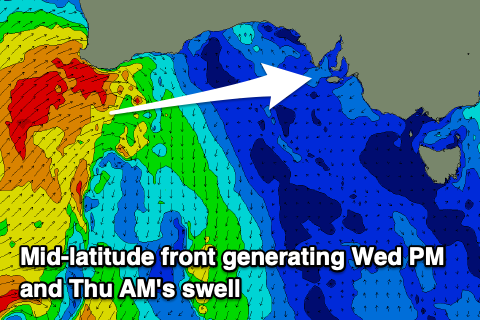 This will be as a slow moving mid-latitude front/trough pushes in from the west, bringing an additional mid-period W'ly swell for the Mid Coast for the afternoon. The front is currently pushing across Western Australia, generating a great fetch of strong to gale-force W/SW winds in the Mid's swell window.
Size wise, the swell should kick later Wednesday to 2-3ft on the Mid Coast, easing from a similar size Thursday, while the South Coast doesn't look to be impacted with the fetch sitting too far north.
Winds unfortunately won't really improve for the Mid Coast Thursday with a fresh W/SW breeze due to strengthen through the day, W/NW for a short period around Victor at dawn with easing 2-3ft sets.
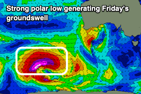 Friday will then see strong S/SW tending S winds as the trough clears to the east. This will spoil a new, moderate-large, inconsistent SW groundswell discussed last week. The swell will originate from a strong, deep polar low that's currently around the Heard Island region, with a fetch of storm-force W/SW winds due to be projected east, only weakening once south-southwest of WA Wednesday morning.
The Mid Coast looks to only come in at 1-2ft with a mix of windswell, with the South Coast due to build to 4-6ft across Middleton through the morning but with that poor wind.
We'll hopefully see more variable winds on Saturday morning with the swell easing back from the 4ft range across Middleton.
Longer term a moderate sized, inconsistent W/SW groundswell looks to fill in Sunday, then easing into next week with winds from the north-eastern quadrant, but we'll have a closer look at this Wednesday.