Poor end to the week, cleaner weekend but fading swell

South Australian Surf Forecast by Craig Brokensha (issued Wednesday June 9th)
Best Days: Mid Coast for the super keen tomorrow morning, South Coast for the keen Saturday morning, Mid Coast late Tuesday and Wednesday, South Coast Wednesday
Features of the Forecast (tl;dr)
- Mix of easing W/SW swell and S'ly windswell tomorrow with strong S'ly winds (tending S/SE at times)
- Smaller surf Fri with moderate S tending S/SW-SW winds
- Cleaner conditions over the weekend but with a small, fading swell
- Inconsistent W/SW groundswell building late Tue, peaking Wed AM with fresh E/NE winds
Recap
What a crazy day of weather and waves yesterday. We saw a building W/SW swell and S'ly windswell as a strong cold front come mid-latitude low pushed in and across us, swinging winds from the W/NW to S/SE down South, providing improving conditions on the Mid but with the afternoon high tide.
Today the W/SW swell energy is still providing 2-3ft sets on the Mid Coast but with a gusty, cross-shore wind, poor and stormy on the South Coast.

Workable waves this AM
This week and next (Jun 10 - 18)
The deep cold pool of air and mid-latitude low responsible for our current cold, wet weather will continue to dominate our weather and surf into the end of the week, only weakening its grip on the weekend as it starts to push off towards New Zealand.
Currently it's located across Victoria and we'll see strong S'ly winds persist tomorrow, tending S/SE at times and then weakening Friday but remaining moderate in strength, tending S/SW-SW into the afternoon.
Swell wise, the current W/SW energy will drop quickly from this afternoon, further overnight leaving 1ft to possibly 2ft sets on the Mid Coast (more likely 1-1.5ft) and the South Coast will see a poor S'ly windswell to 3-5ft.
The windswell will fade Friday from the 2-3ft range down South, tiny on the Mid Coast and come Saturday we should see a variable, light N/NW offshore down South but not much in the way of swell.
An inconsistent, background SW swell from distant frontal activity may provide 1-2ft waves across Middleton, fading through the afternoon as winds tend variable. Sunday looks tiny as does Monday with light N/NE tending E'ly breezes.
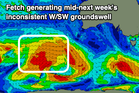 Looking at Tuesday and a new, inconsistent W/SW groundswell is due to arrive late in the day, peaking through Wednesday. The source of this swell will be a very distant storm, firing up west of the Heard Island region tomorrow morning, then pushing east while generating a fetch of strong to gale-force W'ly tending W/SW winds. The storm will break down south-west of Western Australia resulting in a fair bit of swell decay and drop in inconsistency.
Still we should see the Mid Coast offering infrequent 1-2ft surf on Wednesday (possibly kicking to 1-1.5ft by dark Tuesday) with 2-3ft sets across Middleton. Winds look favourable and out of the E/NE-NE but we'll confirm this on Friday.
Longer term a couple of similar if not slightly better swells are due late week and next weekend but winds look dicey and variable as a mid-latitude low moves across us.