Large swell to end off the week

South Australian Surf Forecast by Craig Brokensha (issued Wednesday April 21st)
Best Days: Tomorrow afternoon South Coast, Friday South Coast, keen surfers on the Mid, Saturday morning for the keen on the Mid, Saturday morning down South and early Sunday, Monday and Tuesday mornings down South
Features of the Forecast (tl;dr)
- Building mix of swells Thu, strong late with dawn W/NW winds shifting W/SW shortly thereafter
- Large SW groundswell Fri with moderate SW winds (likely early W around Victor)
- Easing, large S/SW groundswell Sat with W/NW tending W/SW-SW winds (variable early on the Mid)
- Moderate sized, easing S/SW swell Sun and Mon with variable W winds early Sun, N/NE Mon AM
Recap
Choppy conditions on the Mid yesterday and clean in protected spots down South ahead of a change mid-morning. Today winds have quickly swung back offshore along with a fun 2-3ft of swell across Middleton, 1-1.5ft on the Mid Coast.
This week and weekend (Apr 22 - 25)
We've got a temporary low point in swell tomorrow morning before large surf graces the coast again into Friday and Saturday.
This run of large surf will be associated with a deep, intense polar low that formed on Monday, dropping over 24hPa within 24 hours classifying it as a 'bombing' low.
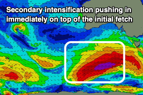
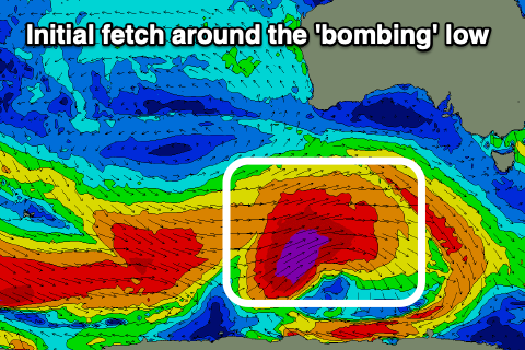 A great, broad fetch of severe-gale to storm-force W/SW winds are being generated around the low, with it forecast to project east-northeast towards Victoria while weakening slightly. The secondary front firing up immediately on the back of the low should generate additional severe-gale W/SW winds, helping prolong the large groundswell event after the initial increase Friday.
Looking at tomorrow and we'll see some mid-period energy building ahead of the groundswell that's due into the evening, with small 2ft waves across Middleton, tiny on the Mid Coast, increasing late to 3-5ft and 1-1.5ft respectively.
Winds will be poor for the Mid Coast and fresh from the W/SW, clean for a period early down South and from the W/NW, shifting W/SW mid-morning.
Friday should see large 6-8ft waves across Middleton with 8-10ft sets likely on the deep water reefs and magnets. The Mid Coast looks to come in at 1-2ft due to the swell direction.
 Winds will be workable and moderate from the SW, with a window of early W'ly breezes likely around Victor. Either way without too much wind there should be a few options.
The swell will still be large into Saturday morning owing to that secondary strong front pushing through, with easy 6ft sets across Middleton, easing during the day, 1-1.5ft on the Mid Coast.
Winds look favourable and light W/NW across the South Coast in the morning, variable SE on the Mid Coast, SW into the afternoon.
Conditions on Sunday look a touch dicey down South with a light SW'ly, though we'll likely see early W winds again down South, shifting S through the day and clean on the Mid. The swell will be easing further though down from 3-4ft across Middleton and 1ft on the Mid.
The easing trend will be slowed a touch by weaker, trailing polar frontal activity behind the low and frontal progression proper, keeping the South Coast active with fun surf early next week as winds shift to the N/NE-NE each morning.
Longer term, as touched on last updates there's nothing too major with small-moderate, mid-period W/SW swells for next weekend and beyond, but more on this Friday.