Stronger swell tomorrow with light winds

South Australian Forecast by Craig Brokensha (issued Monday 14th September)
Best Days: Tomorrow both coasts, Wednesday down South, Saturday down South
Recap
Friday's swell eased into Saturday leaving small, clean 1-2ft waves down South, 1ft to occasionally 2ft across the Mid Coast.
Sunday wasn't to flash down South but a little bigger while an inconsistent new W/SW groundswell continued to provide 1ft to occasionally 2ft sets on the Mid Coast.
Today we've seen a stronger SW groundswell on the build with lumpy/bumpy 1-2ft sets developing on the Mid Coast, better down South and to 3-4ft this morning, bigger this afternoon but now onshore.
This week and weekend (Sep 15 – 20)
 Today's building, and tomorrow's peak in long-period groundswell have been produced by a drawn out progression of Southern Ocean fronts, generating various fetches of gale to severe-gale west to west-southwest winds through our south-western swell window. This has been the case since the weekend through this morning.
The strongest of the fronts is now passing across and under Tasmania (on top the active sea state created before it), with the largest pulse of long-period SW groundswell from this source due to fill in tomorrow.
Middletons should offer 4-5ft+ waves, with 5-6ft sets on the deep water reefs, then easing slowly from 3-5ft on Wednesday owing to the prolonged and drawn out nature of the swell generating progression.
The swell won't be as favourably aligned for the Mid Coast but infrequent 1-2ft sets should continue to be seen on the favourable parts of the tide tomorrow, tiny Thursday.
Winds over the coming two days look great, with local offshore breezes tomorrow, (NE down South and E/NE-NE on the Mid Coast) ahead of weak afternoon sea breezes, similar Wednesday but more N/NE ahead of a shallow change.
This change and trough will see a high quickly move in behind it, swinging winds to the SE on Thursday as the swell continues to ease, tiny on the Mid and average to poor down South.
 Winds should swing back to the E-E/NE on Friday morning but with the swell reaching a low point, it won't be too flash down South and sloppy/junky.
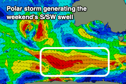
Saturday looks much better with a new S/SW groundswell filling in and better NE offshores. The source of the swell will be a good polar front moving in along the shelf, generating a broad fetch of W/NW gales through the middle to end of the week.
The swell will build through the day, reaching 3ft across Middleton into the afternoon, tiny on the Mid Coast, then easing Sunday. Conditions on Sunday are unclear as the models diverge regarding mid-latitude low/trough moving in from the west, possibly bringing a change, so we'll review this Wednesday and Friday.
Longer term this mid-latitude activity looks to reduce the swell potential across our region and a high maybe bring south-east winds. More on this Wednesday though.