Varying winds and swells swinging from west to south

South Australian Forecast by Craig Brokensha (issued Friday 31st July)
Best Days: South Coast tomorrow, both coasts Sunday, Mid Coast Monday, keen surfers Mid Coast Tuesday
Recap
Fun waves all day yesterday and continuing this morning across the South Coast with 2-3ft sets off Middleton and favourable winds. The Mid Coast was calm and to 1-1.5ft yesterday morning before heavy fog moved in and lasted into the evening. Today conditions were clean and with 1-2ft sets early but a northerly breeze has come up adding small peaks with a drop in size slightly to 1-1.5ft.
This weekend and week (Aug 1 - 7)
Another pulse of fun sized W/SW groundswell is due to fill in tomorrow across both regions, generated by the final front in a conveyer belt of systems moving in from the southern Indian Ocean.
Conditions will deteriorate on the Mid Coast though with a moderate to fresh N/NE tending N/NW breeze, best down South. Inconsistent sets to 1-2ft are due to continue on the Mid Coast swell magnets on the favourable parts of the tide while the South Coast will see 2ft sets across the Middleton stretch.
 Similar sized surf is due Sunday morning and we'll see winds tend more variable the South Coast with a weak trough. The Mid Coast looks clean though with a light morning offshore and afternoon sea breezes.
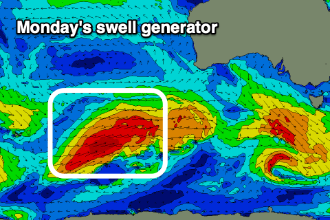
A new W/SW groundswell is due to build into the afternoon though with more consistent 2ft sets on the cards across the Mid Coast later ahead of a peak Monday.
This swell is being generated by a strong polar front that's pushing north-east towards WA and the Bight while generating a good fetch of W/SW gales. It'll weaken on approach, with the swell due to peak Monday to a fairly consistent 2ft, with the South Coast coming in at a good 3-4ft in the morning, reaching 4-5ft on the sets into the afternoon.
Winds are unfortunately average and onshore for the South Coast as the trough moves east Monday, bringing freshening S'ly winds (that may be light at dawn), cleaner and better on the Mid Coast.
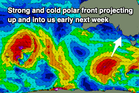 On Wednesday I noted that the models were wildly divergent moving into early next week and it looks like we've seen them marry up a bit and fall half way between what the leading global models EC and GFS were forecasting.
What this is is a deepening mid-latitude low across southern Western Australia and a strong polar front projecting up and towards us early next week, bringing a large S/SW groundswell for Tuesday to the 6ft range across the South Coast.
Unfortunately winds will remain onshore from the S/SE on Tuesday with the large S/SW groundswell, possibly improving Wednesday but the models diverge regarding this. More on the tricky outlook for next week on Monday. Have a great weekend!