Less than ideal weekend, better next week

South Australian Forecast by Craig Brokensha (issued Friday 3rd July)
Best Days: Both coasts early tomorrow, South Coast Monday through Thursday
Recap
A strong increase in new W/SW swell yesterday though strong onshore winds made for average conditions across the Mid Coast as the swell reached 3-4ft. Protected spots on the South Cost offered better conditions in protected spots but the westerly angle of the swell limited the size seen in these locations.
Middleton kicked to a good 4ft through the afternoon, with similar sized, inconsistent but clean sets seen this morning, though a strong onshore change has now moved through. The Mid Coast continued to see plenty of size but with the persistent onshore wind.
This weekend and next week (Jul 4 - 10)
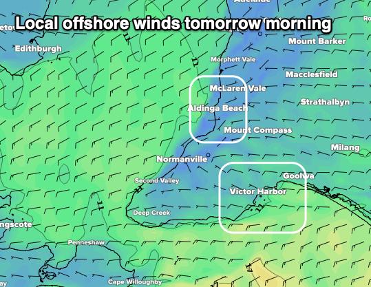 A surface trough has moved through bringing this morning's change and we're now looking at windows of lighter and more variable winds across both regions tomorrow morning. We'll see the size easing back across both coasts, from 2ft on the sets on the Mid and 2-3ft off Middleton and with an early W/NW breeze around Victor, variable out of the E on the Mid (shown by hi-res modelling right).
Conditions will deteriorate through the day as winds shift back to the W/SW-SW from late morning/midday as a weak front pushes up and towards Victoria.
This front will unfortunately now leave lingering onshore S/SW winds on the South Coast Sunday as the swell becomes smaller with a weak S/SW windswell to 2ft+ or so. The Mid should see clean conditions but the swell looks tiny and to 1ft max.
Into Sunday afternoon some new inconsistent SW groundswell is due, though a peak is expected on Monday morning. The source of this is an elongated frontal progression through the south-east Indian Ocean, with pre-frontal W/NW-NW strong to gale-force winds moving less than ideally through our swell window.
In any case a fun kick in inconsistent swell is due to 2-3ft off Middleton Monday morning, while the Mid Coast is likely to hold around 1ft, perfect for beginners.
Variable tending locally offshore winds should create clean conditions Monday morning ahead of weak sea breezes.
Tuesday's pulse of swell from a deepening low under the country this weekend is still on track, with it forecast to be a bit stronger.
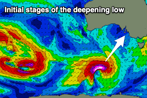 The low will form well south of WA tomorrow evening, with a fetch of severe-gale to storm-force W'ly winds tracking less than ideally through our swell window, but with the strength of the broadening low we'll still see some decent size. As the low weakens slightly it'll be slow moving along the polar shelf in our southern swell window, prolonging the swell event.
The long-period swell should arrive late Monday and peak Tuesday morning with 3ft+ sets across Middleton, though the Mid will be tiny. Wednesday should remain around 3ft or so before easing into the afternoon and small Thursday.
Winds will be favourable out of the N/NE-NE on Tuesday and great from the N'th all day Wednesday.
Longer term an upper level block will lead to a slow period across the South Coast through the rest of the week, while a weak mid-latitude frontal progression near WA may generate some small W/SW swell for the Mid. But more on this Monday. Have a great weekend!