Mixed weekend of swell and winds, average most of next week

South Australian Forecast by Craig Brokensha (issued Friday 19th June)
Best Days: Later tomorrow South Coast, Sunday keen surfers on the Mid, later next week onwards
Recap
Wednesday's large swell eased from a great and pumping 4ft on the sets across Middleton yesterday morning, back to 2-3ft into the afternoon, with small and wind affected waves on the Mid Coast, tiny into the afternoon.
This morning the swell is all but gone, only surf able at Waits and Parsons with bumpy 1-1.5ft waves on the Mid.
This weekend and next week (Jun 20 - 26)
With the large swell through the week bottoming out, we then look to the source of new swell due over the weekend.
 Firstly for the Mid Coast there'll be a very inconsistent but decent increase in W/SW groundswell tomorrow afternoon, generated by the initial stages of a mid-latitude low that's currently sitting south-west of us. This should provide inconsistent 2ft sets across the Mid into the afternoon, while there's likely to be some additional windswell as the north arm of the low starts to push into us. This will bring strengthening W/NW winds through tomorrow, and the South Coast will be clean but tiny in the morning, with an afternoon increase in new S/SW groundswell (discussed below).
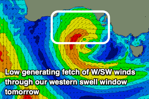
Now, the northern arm of the low will project a fetch of strong W/SW winds through the Mid Coast's swell window tomorrow, kicking up 2-3ft of close-range W/SW swell for Sunday but with gusty S/SW-SW winds. While not ideal there should be some OK options for keen surfers.
Moving back to the South Coast and tomorrow afternoon's late increase in S/SW groundswell is on track, mixed in with small levels of W/SW groundswell. The S/SW groundswell was generated yesterday by a polar fetch of gale to severe-gale W/SW winds late in our swell window and we should see Middleton building to 2-3ft late. With the W/NW winds, protected spots will be the pick.
Sunday will be poor with the onshore change and mix of windswell coming in at 3ft across Middleton.
It looks like we'll see onshore S/SW winds persist through Monday as the W/SW and S/SW swells ease, bottoming out in size Tuesday with lingering SW winds across the South Coast, cleaner on the Mid but tiny.
We then look at the strong mid-latitude frontal progression that's due to move in and across WA through next week. The models still diverge regarding the secondary stages of the progression and whether it will continue east and across is. If it does so winds will be initially NW to SW with the peak of swell, better as it eases. But if it doesn't the swell will be smaller but with cleaner conditions. More on this Monday. Have a great weekend!