Solid, easing swell with good to great conditions

South Australian Forecast by Craig Brokensha (issued Wednesday 3rd June)
Best Days: Thursday and Friday down South, Mid Coast tomorrow for beginners, South Coast Saturday, Sunday and Monday mornings
Recap
Good waves in protected spots on the South Coast yesterday morning with a good mix of SW and S'ly swells to 3-4ft off Middleton, OK into the afternoon as well as winds shifted more onshore. The Mid Coast was tiny and choppy all day.
Today we've got a switch in conditions with S'ly winds across the region creating poor conditions down South while the Mid is cleaner and seeing 1ft to occasionally 2ft sets on the swell magnets.
We should see the size continue to increase on the South Coast this afternoon with a mix of short-range S/SW swell from the front linked to the onshore change pushing into us, but also a new long-period S/SW groundswell. Sets to 4-6ft are due late on the South Coast, holding 1-1.5ft on the Mid Coast.
This week and weekend (Jun 4 - 7)
Later today's mix of S/SW swells will peak overnight and start to ease through tomorrow but we should still see plenty of sizey surf tomorrow morning, with sets to 4-6ft across Middleton easing through the day. The Mid Coast should drop back to 1-1.5ft on the favourable parts of the tide and conditions will be great down South with a N/NE offshore, likely giving into E/SE sea breezes. The Mid should be clean with NE tending variable winds.
Come Friday a N/NW offshore will create great conditions again down South as the swell continues to ease from 3ft off Middleton, 1ft on the Mid Coast. The afternoon will be bumpy with sea breezes.
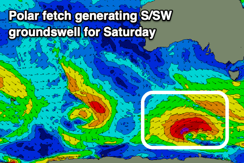 Our new S/SW groundswell for Saturday is still on track and conditions are looking better through the morning with variable N'y winds ahead of weak afternoon sea beezes and then a stronger S'ly change into the evening as a surface trough moves up from the south.
The groundswell will be produced by a polar low that's due to form in our southern swell window, south of WA this evening. A fetch of W tending W/SW gales will be produced on an active sea state generated by pre-frontal NW winds, with a fun kick in size to 3ft due across Middleton Saturday. This swell may not be there in the morning but should be in by early afternoon, with the swell then ease back from 2-3ft on Sunday morning.
The Mid Coast will become tiny to flat through the weekend owing to the unfavourable S'ly swell direction.
With the weak nature of the trough winds are likely to swing back to the E/NE on Sunday morning creating OK conditions but better Monday with a N/NE offshore as the S/SW swell hangs in at 2-3ft before easing into the afternoon. The reason will be a secondary weaker polar front moving in behind the low on the weekend, producing a reinforcing mid-period S/SW swell.
Longer term a blocking high will slowly move in from the west next week as strengthening polar storms squeeze its southern flank. We may see some fun S/SW groundswell spreading up from this activity mid-late week, but we'll have a closer look at this Friday.