Solid swell for the weekend though onshore, better next week

South Australian Forecast by Craig Brokensha (issued Friday 10th April)
Best Days: Sunday keen surfers down South, every morning next week down South
Recap
Good and fun waves across the swell magnets on the South Coast yesterday morning and not too bad into the afternoon with weak sea breezes.
Today there was still a tiny wave on offer, best across the swell magnets and ahead of a strengthening W/NW breeze. The Mid Coast was flat yesterday and similar today, though a poor and tiny windswell will develop into this afternoon.
This weekend and next week (Apr 11 - 17)
Today's freshening W/NW winds are linked to a strengthening and approaching cold front to our south-southwest, with a tight embedded low due to form as it projects towards Victoria this evening.
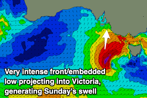 This will project a fetch of SW-S/SW gales through our southern swell window. A moderate to large sized kick in S/SW swell is due from this storm, with an increase in windswell ahead of it tomorrow morning with strong SW tending S/SW winds.
The South Coast looks to start around a poor and weak 2-3ft off Middleton, but kick later in the day to 4ft later in the day, but Sunday morning will produce the most size and strength to the swell with sets to 4-5ft off Middleton.
The Mid Coast will be choppy and 1-2ft or so tomorrow, tiny and clean Sunday to 1ft+.
Winds on Sunday will be much better and workable for keen surfers down South with a light to moderate S/SE breeze, possibly even tending E/SE, a touch fresher into the afternoon.
Moving into Monday, we'll see winds shift offshore from the N/NE and Sunday's swell is expected to continue to drop back from 2-3ft off Middleton.
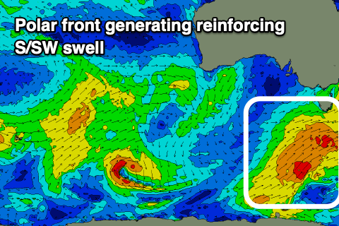 Our new reinforcing S/SW swell for Tuesday is still on track, with a polar front firing up over the weekend expected to produce a good fetch of broad and strong SW winds while projecting just east of Tassie.
We should see fun 3ft sets persisting across Middleton on Tuesday (if not for the odd sneaky bigger one) when the swell peaks and with great offshore N/NE winds ahead of E/SE sea breezes.
Wednesday will be clean all day under strengthening offshore N/NE tending N/NW winds, but the swell smaller and easing from 2ft+ or so off Middleton.
Also in the Mix Wednesday may be a tiny and weak W/SW swell from a weakening front passing across the south-west corner of WA on Sunday. I wouldn't expect anything over 1ft though across the Mid Coast.
Longer term, as discussed last update, there's plenty more swell on the way as it looks like the Southern Ocean will be over-active in our medium-range swell window for at least the next fortnight.
This will produce plenty of swell with what looks to be favourable winds as the storms stay at arms reach. More on this Monday though. Have a great weekend!