Favourable winds and swells from the south-west to west

South Australian surf forecast by Craig Brokensha (issued Friday 27th March)
Best Days: South Coast all weekend, Mid Coast Monday and Tuesday, South Coast from Tuesday
Recap
Plenty of swell across the South Coast again yesterday with average conditions at dawn, improving through the morning and OK with the sea breeze into the afternoon, flat on the Mid.
Today the swell has eased off a little with cleaner conditions and varying winds down South, fun from Goolwa to Parsons, tiny to flat on the Mid Coast.
This weekend and next week (Mar 28 – Apr 3)
Looking at the weekend ahead and more strength and conviction to the offshore wind will create much straighter and clean conditions across the South Coast, with smaller amounts of swell.
A temporary low point is due tomorrow morning, back to 2ft off Middleton ahead of a small kick in S/SW groundswell into the afternoon, generated by a poorly aligned polar front yesterday. A little increase to 2ft+ is due off Middleton into the afternoon, easing from 2ft Sunday with the Mid Coast remaining tiny to flat.
Coming back to the winds tomorrow and a moderate N/NE wind through the morning is expected to shift N/NW and variable into the afternoon, with Sunday seeing dawn N/NE winds, shifting N/NW and then W/NW into the afternoon and more W'ly later afternoon.
A low point in swell is due early Monday with a W/NW breeze, shifting SW later morning along with a building mid-range W/SW swell.
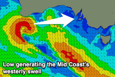 The source of this swell will be a tight mid-latitude low moving in from the south-west of WA, directing a fetch of strong to gale-force W/SW winds through our western swell window, weakening as it pushes through the Bight tomorrow.
The swell will be ideally aimed for the Mid Coast, filling in Monday and reaching 2ft to occasionally 3ft with those workable moderate onshore winds.
The South Coast isn't expected to see too much size, with an afternoon increase to 2ft+ off Middleton.
Of greater importance is the moderate to large, long-period SW groundswell due Tuesday.
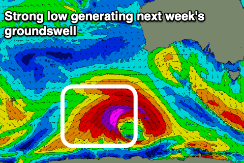 A deep and intense polar low is forecast to form east of Heard Island this evening. We'll see a fetch of severe-gale to storm-force winds projected through our south-western swell window as the low expands, weakening rapidly from Sunday but still projecting a cold front off its northern arm towards us Sunday. This will generate an additional weak SW swell to the mix Tuesday morning.
Looking at the arrival time and we should see the swell building through Tuesday from the morning, peaking into the late afternoon and building from 3ft off Middleton to 4-5ft, while the Mid Coast looks to drop back to 2ft+.
Conditions are looking favourable for both regions with light local wind, offshore in the morning ahead of sea breezes.
The swell should ease into Wednesday, slowed by some reinforcing pulses of background swell, and winds look generally favourable, light in the mornings with clean conditions. More on this Monday, have a great weekend!