Mostly average period with limited surfing opportunities

South Australian Forecast by Craig Brokensha (issued Friday 6th March)
Best Days: Keen surfers Wednesday morning, Thursday morning
Recap
A bit of size left in the mix yesterday but with onshore winds on the South Coast and no quality, tiny to flat on the Mid Coast.
Today is smaller and choppy and a definite lay day down South, flat and bumpy on the Mid.
This week and weekend (Mar 7 - 13)
After an average couple of days of waves, with got more poor surf due down South over the weekend.
There'll be no real groundswell in the mix, with poor quality S/SE-S windswell and generally onshore S/SE winds.
Tomorrow morning winds should tend more E/NE-E for a period through the morning, but with onshore winds right up until dawn, it'll be mostly junky and poor.
Sunday looks to play out similar, and swell wise I wouldn't expect much over 2ft+ of weak windswell across Middleton.
The Mid should be clean most of the weekend, but flat.
Unfortunately moving into Monday winds look to hold from the SE through the morning, freshen S/SE into the afternoon, E/NE-E on Tuesday morning but with no decent swell again.
 Our mix of inconsistent long-period SW groundswell and mid-period S/SW swell for Wednesday are on track, but again no major size is expected.
The distant low linked to the groundswell has generated a fetch of severe-gale W/SW winds in our far swell window, and will push along the polar shelf in a weaker form this weekend generating strong W'ly winds.
Both swells should fill in overnight Tuesday and peak Wednesday to a small and inconsistent 2ft off Middleton, flat on the Mid Coast.
Winds are due to swing more E/NE-NE through the morning on Wednesday creating cleaner conditions, even better Thursday and from the N/NE with a slightly stronger S/SW groundswell.
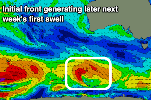
This groundswell will be produced by a strengthening but not overly significant polar front, the first in a succession of stronger systems behind it. It isn't due to offer much size, with possibly 2ft+ sets off Middleton if we're lucky with that nice offshore wind.
The stronger trailing polar fronts should produce a better S/SW groundswell for late week/Saturday but unfortunately winds look poor and strong from the S/SE-SE as a trough moves in from the west, followed by a strong high. More on this Monday though. Have a great weekend!
Comments
......um.......ok