Poor run continues, cleaner next week but small to tiny

South Australian Forecast by Craig Brokensha (issued Wednesday 4th March)
Best Days: Desperate surfers Saturday and Sunday mornings down South, Wednesday and Thursday mornings down South
Recap
Plenty of swell across the South Coast yesterday and today, but onshore winds have created generally poor conditions, lighter today with the best pulse of S/SW groundswell. The Mid has been effectively flat with micro lines of unsurfable swell.
This week and weekend (Mar 3 - 8)
Unfortunately this morning was really the best morning of the period, with winds expected to freshen out of the S/SE this afternoon as the remnants of Tropical Cyclone Esther drift south-east across NSW and Victoria, squeezing a high to our west-southwest.
The S/SW groundswell will ease tomorrow with moderate to fresh S'ly tending S/SW winds, strengthening later. Size wise Middleton should ease back from 3ft or so, with a poor quality windswell taking its place on Friday as it drops further along with fresh to strong S/SW tending S winds.
No swell is due on the Mid Coast with just tiny windswell ripples from the S/SW winds.
We should see winds tend E-E/NE on Saturday morning down South, providing slightly cleaner conditions but size wise, there's only expected to be a small 2ft of windswell off Middleton.
Sunday looks similar with possible E-E/NE winds in the morning and a S/SE windswell to 2ft+ or so.
 Winds should start improving through next week but swell wise, we'll be looking at small, inconsistent background energy.
Monday will likely be small to tiny with a morning NE breeze, cleaner Tuesday but smaller again and better Wednesday as a mix of inconsistent SW groundswell and mid-period S/SW swell will in.
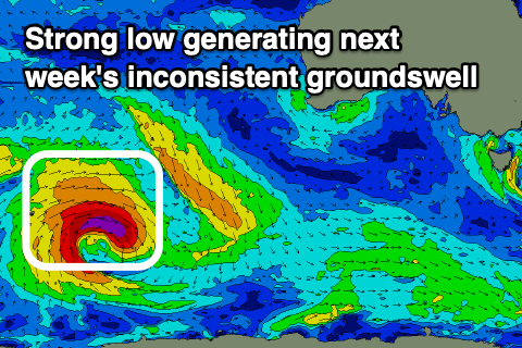
The swell will be generated by a strong polar low forming just east of the Heard Island Friday morning.
It'll project a good fetch of gale to severe-gale W/NW winds through our far swell window, before tracking along the polar shelf, under the country in a much weaker form.
We should see Middleton coming in at a small 2ft+ Wednesday, a touch smaller Thursday, better at more exposed beaches and with morning N/NE offshores. Longer term there's some better polar frontal activity mid-late next week generating swell for next weekend, but we'll have a closer look at this on Friday.