More power to the swells from next week

South Australian Forecast by Craig Brokensha (issued Wednesday 19th February)
Best Days: Mid Coast for beginners tomorrow, South Coast desperate surfers Saturday and Sunday mornings at exposed breaks, South Coast Monday morning
Recap
Poor conditions with building windswells across both coasts yesterday with strong onshore winds, reaching 2-3ft on the Mid and similar down South.
Today conditions have improved across the Mid with sets to 2ft and workable winds out of the south, choppy and 3-4ft on the South Coast.
This week and weekend (Feb 20 - 23)
The W/SW swell currently breaking on the Mid Coast will start to ease into tomorrow while cleaning up. Unfortunately we'll be looking at only 1-1.5ft sets with a morning S/SE-SE breeze, bumpy and onshore down South with an easing mix of groundswell and windswell from 3ft on the sets across Middleton. Also the period of E/NE winds isn't on the cards any more.
Friday isn't looking any better with onshore SE tending S/SE winds, freshening through the day and no new swell.
Moving into the weekend and Saturday looks to become a little cleaner on the South Coast with an E/NE breeze but again there's no new groundswell on the cards. Just background SW energy and S/SE windswell to 2ft or so off Middleton.
Lighter NE winds are due on Sunday morning but with 1-2ft waves max off Middleton
Moving into next week and a new inconsistent but long period SW groundswell is due Monday and Tuesday, generated by a strong polar low firing up around the Heard Island region.
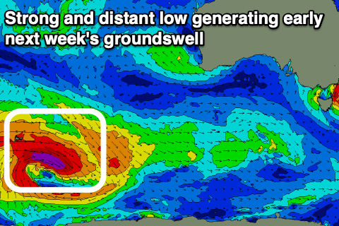 The low is forecast to generate a great fetch of pre-frontal severe-gale to storm-force W/NW winds in our far swell window.
The low will weaken slowly while moving further east and under the country, but we should see a moderate sized, though inconsistent long-period SW groundswell, possibly showing late Sunday but peaking through Monday to 3-4ft off Middleton, but tiny on the Mid and only to 0.5-1ft.
Winds at this stage are looking variable out of the east on Monday morning, light to moderate onshore Tuesday as the swell eases, but we'll have to have a closer look at this on Friday.
Into the end of the week and weekend we're looking at a couple of possible moderate to large sized S/SW swells from a strong polar frontal progression pushing up and close to us, but we'll go over this again on Friday.
Comments
Still a few fun lil' waves on the Mid this AM.
