No fun for the South Coast, focus on the Mid

South Australian Forecast by Craig Brokensha (issued Monday 10th February)
Best Days: Mid Coast early and later tomorrow and Wednesday morning, Mid Coast next week
Recap
Poor surf Saturday with a junky windswell and onshore winds down South, much better yesterday with offshore winds and a peaky mix of S/SE and S/SW swells easing from 2-3ft on the exposed beaches. The Mid Coast was flat all weekend.
Today is tiny down South and flat on the Mid again, but a new W/SW groundswell should show later in the day on the Mid, with it just pinging on the Cape du Couedic wave buoy.
This week and weekend (Feb 11 - 16)
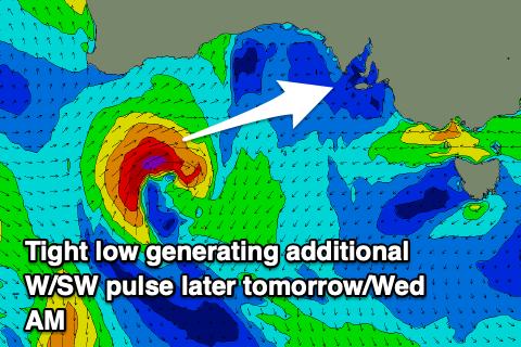
The W/SW groundswell that's due to show later today on the Mid should kick to 1ft by dark, with a peak expected tomorrow to an inconsistent 1-2ft on the favourable parts of the tide. We've got a better reinforcing pulse for the afternoon now though with the remnants of the storm forming a tight low under WA yesterday, producing an additional 2ft+ kick into the later afternoon/evening, easing Wednesday from 1-2ft.
The South Coast should see inconsistent 2-3ft sets across the Middleton to Goolwa stretch, but winds are still a big issue. Onshore S/SW tending S'ly breezes are due down South, S/SE tending SW on the Mid, creating less than ideal conditions, but back to the S/SE late.
Wednesday will be best on the Mid again with strong S/SE winds as the W/SW swells ease while a junky S/SE windswell builds down South.
 We'll see winds ease off into Thursday on the South Coast but linger onshore out of the SE, creating average conditions as the S/SE windswell eases, and then swinging S/SW into Friday along with an inconsistent new SW groundswell.
The source of this swell is a more distant polar low than the storm linked to tomorrow's swell and as a result no major size is expected and it'll be very inconsistent. The Mid Coast is due to be tiny and to 0.5-1ft with 2ft sets off Middleton.
The weekend will be poor with strengthening onshore S'ly winds and a junky windswell across the South Coast, flat on the Mid but heading into next week we're looking at a fun W/SW groundswell for Tuesday/Wednesday.
A good mid-latitude frontal progression is forecast to fire up west-southwest of WA later week, generating a great fetch of W/SW gales through our western swell window, dipping south-east on Sunday and under the country.
The swell should build Tuesday afternoon and peak Wednesday around 2ft or so on the Mid and 3ft+ across the South Coast along with SE winds. More on this in the coming updates though.
Comments
New swell is in..