Lots of swell inbound, but mostly onshore

South Australian Forecast by Craig Brokensha (issued Monday 25th November)
Best Days: No good days unfortunately
Recap
Poor conditions across both coasts yesterday with strong but easing onshore winds and 1-2ft of windswell on the Mid, building to 3ft down South.
Today the swell was back to a small 2ft off Middleton but nice and clean, best on the swell magnets and a clean 1ft on the Mid.
This week and weekend (Nov 28 – Dec 1)
The end of the week is fairly hit and miss across the region.
The swell will bottom out tomorrow morning and winds are dicey for the South Coast with overnight onshore S'ly winds due to tend variable for a period in the morning ahead of S/SE sea breezes.
Our new S/SW swell for later in the day and more so Friday is still on track, but the timing has been brought forwards a little.
The swell has been produced by a broad but relatively weak low projecting through our swell window the last two days, with it continuing to generate a fetch of W/SW winds in our swell window today.
The swell is due to show into late afternoon tomorrow, likely building to 2-3ft late off Middleton, peaking Friday to 3ft with tiny 1ft waves on the Mid Coast.
Winds unfortunately look to linger out of the S/SE across the South Coast Friday, creating average conditions, clean on the Mid.
The swell will ease into Saturday with strengthening W/SW tending SW winds. There's an outside chance for a dawn W'ly around Victor, but we'll have to review this Friday.
A building windswell will be seen on the Mid, reaching a messy 2ft into the afternoon with those strong onshore winds.
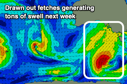 This front will be the first of many projected up and into us, under the influence of a strong node of the Long Wave Trough currently moving in from the west. This node is expected to stall just east of Victoria into the weekend and early next week, slowly weakening later week.
This will project a series of polar fronts up and into us and Victoria from Sunday through at least mid-week if not later next week.
They'll be of various strength and projected between our south-western and southern swell windows, producing moderate to large pulses of SW-S/SW swell from Monday through Friday.
The first swell is expected to fill in Monday, produced by an initial broad and strong polar front projecting from the polar shelf Saturday, south of WA, up and into us on Sunday.
Building windswell is expected across both coasts Sunday afternoon, reaching 3ft on the Mid Coast and 3ft+ down South, with a peak in swell down South Monday to 4-5ft but with strong SW winds.
Secondary frontal activity looks to maintain surf of this size if not a bit bigger through Tuesday and Wednesday with onshore W/SW-SW winds, not relenting until late week. More on this Friday though.