Small week, better swells from the weekend

South Australian Forecast by Craig Brokensha (issued Monday 23rd September)
Best Days: Swell magnets South Coast tomorrow morning, Wednesday morning and Thursday, both coasts Saturday (morning South Coast), South Coast Sunday morning
Recap
Average surf Saturday but a new W/SW groundswell filled in yesterday providing good waves across the Mid Coast with the incoming tide, 2-3ft and clean off Middleton through the morning.
Today the swell has eased off a bit back to 1-2ft on the magnets on the Mid, a small 2ft off Middleton with a morning W/NW breeze, now SW.
This week and weekend (Sep 24 - 29)
This week will be slow and not great for surfing with the size slowly dropping away, at odds to the model guidance. The swell magnets on the South Coast will be best.
There hasn't been any significant storm activity in our swell window since the weekend and this will continue through the coming days, with just a small background mid-period W/SW swell tomorrow, small to tiny thereafter.
Inconsistent 2ft sets are due off Middleton tomorrow morning, easing into the afternoon and back to 1-1.5ft Wednesday and 1ft Thursday. The Mid Coast will become tiny tomorrow and near flat Wednesday.
A morning W/NW breeze will be OK for tomorrow down South, S'ly into the afternoon with sea breezes and better for exposed beaches Wednesday morning and out of the N, giving into SE sea breezes.
Thursday looks clean most of the day with a N tending N/NW breeze but that tiny swell.
As touched on last update we've got a better swell due this weekend, produced by a strong polar low forming in the Heard Island region yesterday afternoon.
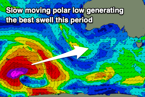 This low is in our far swell window, but a great fetch of slow moving severe-gale to storm-force W/SW winds will be aimed towards us, weakening as it projects to a positioned south-west of WA tomorrow evening and further Wednesday morning.
The swell will be inconsistent, with the forerunners arriving late Friday but the peak in swell is due Saturday with 3-4ft sets off Middleton, with the Mid Coast seeing a very inconsistent 1-2ft wave on the favourable parts of the tide.
Conditions look best on the Mid Coast with an E/SE offshore, E/NE down South but peaky/lumpy conditions ahead of sea breezes across both coasts.
Sunday looks a little cleaner with a light NE offshore down South and easing 3ft sets off Middleton, 1-1.5ft on the Mid Coast.
Moving into Monday, a secondary and likely slightly bigger SW groundswell is due, generated by a secondary strong polar low forming south-west of WA later this week. The low will be shorter-lived but project closer to us, with Monday likely seeing surf to 3-5ft off Middleton, though remaining around 1ft to maybe 2ft on the Mid Coast.
Winds look to hold out of the E/NE-NE through the morning, but we'll have a closer look at this Wednesday.