Large swells incoming, slower but fun weekend

South Australian Forecast by Craig Brokensha (issued Monday 17th June)
Best Days: Mid Coast tomorrow, both coasts Wednesday, Thursday morning South Coast, Sunday South Coast
Recap
The South Coast was great all weekend with clean conditions and a good new S/SW groundswell building through Saturday, easing Sunday under persistent offshore winds. The Mid Coast was small to tiny and best in the mornings.
Today the swell has eased across both coasts along, best across the South Coast swell magnets.
Today’s Forecaster Notes are brought to you by Rip Curl
This week and weekend (Jun 18 - 23)
As discussed in this forum thread here, the wave model data is incorrect for the coming few days owing to an update we did over the weekend. With the model starting from scratch, the swells due tomorrow and Wednesday which were generated mostly before the restart are not showing on the charts.
There's been no real change to Friday's forecast for tomorrow's initial pulse of long-period SW groundswell, and then the follow up and slightly larger W/SW groundswell on Wednesday.
Tomorrow's swell is impacting Western Australia today, offering extra-large surf and we'll see it arriving late today and peaking tomorrow morning. Middleton should see strong though inconsistent 4-5ft sets, with the Mid Coast coming in around 2ft on the sets.
The secondary swell will have a touch more west to its direction but also a little more size. This was produced by a slower moving fetch of severe-gale W/SW winds, with the storm currently passing under the country in a much weaker form.
Middleton should see larger 5-6ft sets Wednesday morning, easing into the afternoon and further Thursday from 3-4ft while the Mid Coast is expected to see a bit more size around 2ft to occasionally 3ft, dropping Thursday from 2ft on the sets.
Winds are still expected to be onshore from the SW across the South Coast tomorrow in the wake of a change early in the morning, while the Mid Coast should see morning S/SE winds and better conditions.
Wednesday looks favourable for both coasts with a light NE breeze on the Mid Coast and N'ly breezes down South, more N/NW into the afternoon.
Thursday will be clean again with a NW offshore though a trough will bring a S'ly change into the afternoon, tending back to the E/NE on Friday as the groundswell continues to drop.
 The weekend will start small and slow, but an inconsistent new long-period SW groundswell is due to build Saturday and peak overnight, easing Sunday.
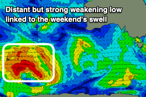
The source of this swell is an intense polar low that's developed south of South Africa and tracked east generating a fetch of severe-gale to storm-force W'ly winds in our far far swell window.
The low is currently around Heard Island and will continue east over the coming days while weakening, breaking down south-southwest of WA on Wednesday. We'll likely see the most consistent size from the later developments, with infrequent bigger set waves every 15-20 minutes as the swell peaks.
Middleton is expected to build to 3ft on the sets later Saturday, easing from a similar size Sunday morning, with those infrequent bigger sets in the mix. The Mid Coast looks to be tiny and only to 1ft.
Conditions will improve all weekend with a morning NE breeze Saturday, SE into the afternoon and then N/NE on Sunday morning.
Longer term there's nothing significant on the cards until later next week when a flurry of mid-latitude fronts push up and over WA, onwards towards us, generating W/SW swells, but more on this Wednesday.
Comments
Big purple blob incoming next week!! Like really big!