Good waves continue down South, with a fun Mid Coast swell

South Australian Forecast by Craig Brokensha (issued Monday 20th May)
Best Days: Keen surfers Mid Coast tomorrow, South Coast tomorrow, both coasts Thursday and Friday (a little bumpy on the Mid), South Coast Saturday
Recap
Tiny on the Mid Coast all weekend with a new W/SW swell due Saturday just teasing, while the South Coast offered great conditions again with a clean and solid kick in new S/SW groundswell on Saturday, easing back through yesterday.
This morning a new S/SW groundswell has kept fun waves hitting Middleton to 2ft, better at swell magnets, while the Mid Coast is a bumpy 1-2ft with an increase in new W'ly swell.
Today’s Forecaster Notes are brought to you by Rip Curl
This week and weekend (May 18 – 24)
The small W/SW swell seen on the Mid Coast today should ease back from 1ft to maybe 2ft tomorrow morning, while a small S/SW groundswell will keep the South Coast active tomorrow. While poorly aligned, a very strong fetch of severe-gale to storm-force W/NW winds skirted through our southern swell window on the weekend, with the swell due to arrive overnight and ease tomorrow.
Size wise, Middleton should ease from around 2ft+, with a bit more size across Waits and Parsons, though not as much as normally expected owing to the southerly angle. Winds will be great for the South Coast and from the N/NW all day, early N/NE on the Mid creating OK conditions for desperate surfers.
Wednesday will be clean again in the morning with a NW offshore, but the swell small to tiny ahead of a weak S'ly change into the afternoon.
Into Thursday our new moderate to large sized W/SW groundswell is due to build through the day, peaking Friday. This is being generated by a slow moving and broad polar front that's currently projecting a fetch of strong to gale-force W/SW winds towards Western Australia.
This front will push further east slowly through our western swell window, today and tomorrow, weakening into Wednesday south of us.
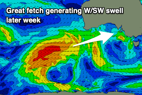 The strength of the fetch wasn't quite as good as expected on Friday, but we should still see a good sized W/SW groundswell, building Thursday and reaching 2-3ft with the help of the incoming tide on the Mid Coast into the afternoon, reaching 3ft+ across Middleton. Friday should reveal 3-4ft sets off Middleton through the morning, easing a little later and with surf to 2ft to possibly 3ft on the Mid.
Conditions will be great across both coasts Thursday morning with a N/NE offshore down South, NE on the Mid, variable into the afternoon. A fresher N/NE breeze will then favour the South Coast Friday, bumpy on the Mid.
The swell should ease slowly Saturday, helped by a reinforcing SW swell from the backside of the low generating Thursday/Friday's swell but following this strengthening frontal systems pushing up and into us look to generate some larger surf from Sunday and early next week. These swells will arrive with wind, but more on this Wednesday.