Clean mix of swells for the weekend, more action from later next week

South Australian Forecast by Craig Brokensha (issued Friday 17th May)
Best Days: Both coasts tomorrow, South Coast Sunday through Tuesday and next Thursday morning (possibly Mid Coast into the arvo)
Recap
The South Coast continued to pump through yesterday and today with a slight drop in size yesterday, increasing again today with a new inconsistent long-period groundswell. Weak easterly breezes developed into yesterday afternoon, while today looks to likely play out similar.
The Mid Coast has been tiny and poor the last two days.
Today’s Forecaster Notes are brought to you by Rip Curl
This week and weekend (May 18 – 24)
Our tricky mix of new W/SW and S/SW groundswell for tomorrow are still on track, with the S/SW energy actually looking a little better.
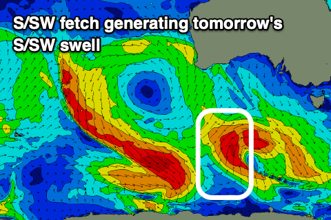 A trough moving in from the south-west of WA generated a weak but favourably aligned fetch of W/SW winds through our western swell window, producing a fun W/SW swell for the Mid Coast. A stronger though less favourably aligned fetch of S/SW gales were produced around a low pressure centre, initially aimed towards the Eyre Peninsula but moving quickly through our swell window yesterday evening.
A better S/SW groundswell should be seen off this low, with it arriving tomorrow morning and providing 3ft+ waves off Middleton, while the W/SW swell should build to 2ft, if not for the odd bigger one across the Mid Coast through the day with the incoming tide.
Winds will be favourable for both coasts and out of the NE tending E/NE on the Mid Coast and similar down South, favouring some spots but not others.
Both swells are still expected to ease into Sunday as a moderate to fresh and persistent N/NE breeze creates great conditions all day down South. Middleton should ease back from 2-3ft, with bumpy easing 1-2ft waves on the Mid Coast.
We've got a couple of small S/SW groundswell pulses on the cards for Monday and Tuesday down South and with favourable winds from the north-western quadrant, while the Mid Coast will see a W'ly swell from a deep mid-latitude low stalling in the Bight. This low is forecast to generate a fetch of strong W/SW winds through our western swell window on Sunday, before dipping south-east across us Monday as the swell fills in.
The Mid Coast should kick to 2ft+ on Monday but with NW tending W/NW winds, while back to back polar lows will generate the S/SW groundswells down South. For our region it looks like Monday's swell will offer more size than the longer-period pulse on Tuesday owing to the first of the late forming lows generating a more favourably aimed fetch of polar W/SW winds earlier in our swell window.
Size wise Middleton should see sets to 3ft Monday, with the secondary pulse maintaining similar size waves, though easing through the day. If we're lucky we'll see winds persist out of the NW all day Monday on the South Coast and N/NW tending NW Tuesday.
The surf should bottom out Wednesday ahead of a moderate to large and building W/SW groundswell through the end of the week.
This swell will be produced by a broad and strong polar low projecting up from the Heard Island region towards and then under WA, generating a slow moving fetch of gale to maybe severe-gale W/SW winds. At this stage wave heights should build Thursday with N/NW winds, peaking Friday with a possible onshore change moving through, but we'll go over this and follow up swells on Monday. Have a great weekend!