Poor weekend, windows of fun waves next week

South Australian Forecast by Craig Brokensha (issued Friday 17th August)
Best Days: Monday morning South Coast, Tuesday afternoon and Wednesday morning South Coast
Recap
A good kick in swell across the South Coast yesterday morning with favourable winds for protected spots. It was a little unorganised and lumpy in the morning, cleaner and better into the afternoon with a drop in size. The Mid Coast saw 2-3ft sets on the magnets though with average conditions.
This morning the South Coast was great again with a straight offshore wind and fun easing 2-3ft of swell off Middleton, while the Mid was back to 1.5ft with a cross-shore wind.
Today’s Forecaster Notes are brought to you by Rip Curl
This weekend and next week (Aug 18 - 24)
The weekend isn't shaping up too well surf wise, with a low point in swell tomorrow morning and an early W/NW breeze, giving into a strengthening W/SW'ly as strong front pushes in and across us.
Middleton is only due to be around a small 2ft max on the sets, while the Mid Coast looks tiny and maybe 1-1.5ft, though kicking quickly to 2ft+ through the day with the strengthening W/SW breeze.
The South Coast will also a building swell, though more so later and from the earlier stages of the storm this week.
We saw the storm develop east of Heard Island during the middle of this week, projecting slowly towards us while generating a fetch of severe-gale W/SW winds. It's currently weakening and projecting strong to gale-force W/SW-SW winds through our south-western swell window and should push across us through tomorrow.
 Middleton looks to build to 4-5ft+ by dark tomorrow though with that strong W/SW wind, while come Sunday we've got poor and strong S/SW winds as the W/SW swell eases, mixed in with some mid-period S/SW swell, continuing around 4ft off Middleton.
The Mid Coast will ease back from the 2ft range but remain bumpy and choppy.
Monday will be much cleaner down South as an approaching front steers winds back to the N/NW though the swell will be easing from 2-3ft or so off Middleton, smaller into the afternoon as winds swing more W/NW.
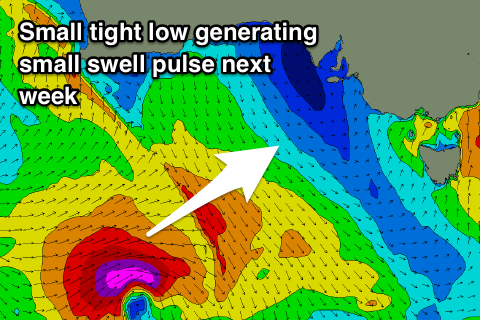
A fun new spike in SW groundswell is due to build later Tuesday and ease Wednesday, generated by a strong but short-lived low firing up well south of WA.
A fetch of severe-gale to storm-force W/SW winds are due, with Tuesday morning starting small and slow (1-2ft max Middleton), kicking to 2-3ft later in the day. We may see a small front spawning off this low bringing average winds, but latest model forecasts have improved in this regard, with light offshore winds due.
Wednesday also looks clean as the swell eases, and looking into the second half of the week, we're due to see a mix of long-range W/SW groundswells from storms firing up in the south-east Indian Ocean. Winds may take a turn for the worse as a mid-latitude low moves in slowly from the west and over us, but we'll review this again Monday. Have a great weekend!
Comments
Absolutely shitful winter this year.
I rekon spring will be good