Good swell building Friday with light winds, easing on the weekend with dicey winds

South Australian Forecast by Craig Brokensha (issued Wednesday 13th December)
Best Days: South Coast late morning-early afternoon Friday, Saturday morning, Monday morning, Mid Coast keen surfers Friday afternoon, Saturday morning and Sunday morning
Recap
OK and improving waves across the South Coast yesterday with a developing offshore NE breeze that held out until about midday. This morning conditions were cleaner and straighter, but the swell tiny and best suited to Waits and Parsons.
The Mid Coast was tiny yesterday and effectively flat today.
Today’s Forecaster Notes are brought to you by Rip Curl
This week and weekend (Dec 14 - 17)
A weakening trough moving in from the west will bring onshore S/SW winds across both coasts tomorrow with tiny leftover amounts of swell.
Moving into Friday though we're set to see a new mid-period SW swell fill in across both coasts, mixed with a longer-range and smaller W/SW swell.
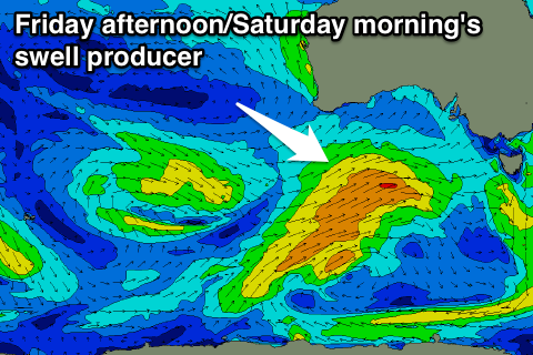 These swells have and will be generated by a slow moving frontal progression through the Southern Ocean, with the system now south of WA.
We'll see a front spawning off this progression this afternoon, projecting a good fetch of strong W/SW winds towards.
A fun sized mid-period SW swell should be seen, building through Friday and peaking late afternoon.
The Mid Coast should see sets building to 1-1.5ft through the afternoon, though without much tidal movement, while Middleton should build to 3ft+.
Winds are looking favourable through the morning and variable, giving into sea breezes early afternoon, so the late morning surf is probably the best pick for size and conditions.
The swell should ease back from a similar size Saturday morning across both coasts but winds are still a little up in the air.
We're likely to see light S'ly winds on the Mid and light W/SW-SW breezes down South, creating workable waves off Middleton.
A secondary front producing a less than favourably aligned fetch of strong pre-frontal W/NW winds should generate a reinforcing SW swell for later Saturday and Sunday morning, keeping Middleton up around 2-3ft early, easing through the day and smaller Monday to 2ft. The Mid Coast should hold in around 1-1.5ft before fading Sunday afternoon.
Winds will be best for the Mid and average for the South Coast Sunday with a moderate to fresh E/SE-E'ly through the morning ahead of S/SE sea breezes.
 Monday will be cleaner down South with a morning NE'ly, but as pointed out above, small and fading.
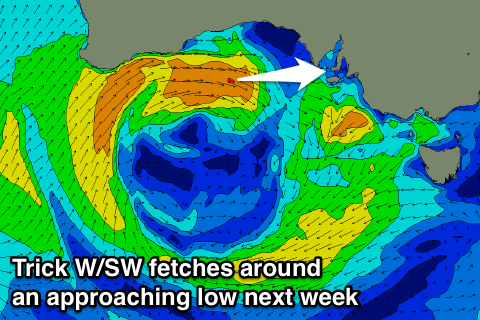
Longer term the outlook is quite interesting and dynamic.
Over near WA a cold front projecting up into the South West will combine with an inland surface trough resulting in the formation of a deep and powerful mid-latitude low.
This low will stall over WA Sunday and Monday before weakening and starting to drift south-east through early next week.
We're expected to see tricky and varying pulses of W/SW swell from Tuesday afternoon through the rest of the week as the low stalls than pushes east. We'll have more info on this Friday.