Variable winds and swells for the state

South Australian Forecast by Craig Brokensha (issued Monday 4th December)
Best Days: Keen surfers South Coast tomorrow morning, magnets Wednesday morning, protected spots Friday morning down South (Mid Coast keen surfers), Saturday morning, Monday morning
Recap
Terrible conditions across the South Coast with gusty S'ly winds and a very poor quality windswell. The Mid Coast didn't fare any better with tiny choppy surf.
This morning the surf was still poor down South and easing while the Mid Coast is bumpy but flat.
Today’s Forecaster Notes are brought to you by Rip Curl
This week and weekend (Dec 5 - 10)
This afternoon we should see a new SW groundswell filling in across the state, but it will be hard to discern under the local S'ly windswell, and Cape du Couedic is yet to pick up any signs of this swell.
In any case Middleton should build to 2ft+ on the Surf Coast, with tiny 0.5ft sets on the Mid, easing back from 2ft and and 0.5ft respectively tomorrow.
Winds are looking workable on the South Coast but conditions won't be great, with a light morning E''y breeze, likely E/NE even before sea breezes kick in.
Wednesday will be back to the small to tiny stuff and a light variable wind should create OK conditions, but you'll have to hit up Waits and Parsons.
 Moving into Thursday and the surf is expected to small to tiny again and clean early with a W/NW breeze, but an incoming trough will bring a strong S/SW change through the day.
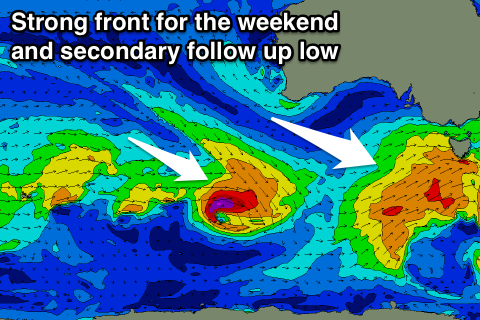
This trough is currently in the form of a weak front south-west of WA, with a fetch of strong W/SW winds due to be generated in our south-western swell window.
A small SW swell should be seen, kicking later Thursday and peaking Friday to 2ft to occasionally 3ft across Middleton, while the Mid Coast should see 1-1.5ft surf, if not for the odd bigger one on the favourable parts of the tide.
Unfortunately winds will still be onshore and from the W/SW across both coasts, though we could see an early W/NW'ly in Victor.
Saturday is a better chance for a morning W/NW breeze as the swell eases back from 2ft off Middleton.
From the weekend we're expected to see some better groundswell across the state, firstly for Sunday and then second Tuesday.
A strengthening cold front passing under us on Friday will generate a good fetch of W/SW gales late in our southern swell window, producing a new S/SW swell for Sunday.
We're looking at fun 3ft sets off Middleton, though with light E/SE winds ahead of sea breezes. Monday looks cleaner as the swell eases, and a secondary good pulse of S/SW groundswell is due Tuesday from a tight low forming on the back of the front. Winds may revert back to the S/SE though, but check back here Wednesday for the latest.