Opportunities for fun waves on both coasts over the weekend, large early next week

South Australian Forecast by Craig Brokensha (issued Friday 27th October)
Best Days: Saturday afternoon Mid Coast, South Coast Sunday morning, keen experienced surfers protected spots Monday, Wednesday and Thursday mornings both coasts
Recap
A continuation of tiny waves across the Mid Coast yesterday and this morning with cleaner conditions, while the South Coast saw a touch more size yesterday though with fresh onshore winds.
Today the surf cleaned up down South with a hot offshore wind, but the swell was tiny off Middleton and only really worth a paddle at Waits and Parsons. Conditions should remain clean ahead of a late afternoon W'ly change.
This weekend and next week (Oct 28 – Nov 3)
Tomorrow will start tiny and slow under a morning W/NW breeze, tending W/SW at some stage through the afternoon.
Our small W/SW swell for the Mid Coast is still on track, with a front passing under WA yesterday producing 1-2ft waves into the afternoon. With winds not being too strong through the day, there'll likely be some fun waves for keen surfers with the incoming tide.
Our new W/SW groundswell for Sunday is still on track, though the peak has been pulled forward to Sunday morning (which is great for the South Coast), with the swell kicking later tomorrow.
A strong front is currently passing under WA's South Coast, projecting a good fetch of strong to gale-force W/SW winds on top an active sea state, through our western swell window.
The front will race quickly through the Bight this evening before dipping away to the south-ease through tomorrow.
A moderate sized W/SW groundswell is due off this front, building late Satutrday to 2ft on the Mid Coast, coming in at 2-3ft on the on the favourable parts of the tide Sunday. The swell should kick to 2-3ft on dark across Middleton tomorrow, peaking Sunday morning to 3ft+ and then easing through the day.
 Winds on Sunday will be best for the South Coast with a strengthening N/NW'ly tending W/NW into the afternoon, so try and get in through the morning.
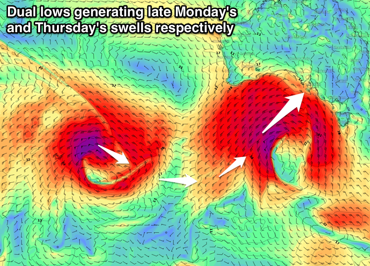
Moving onto the larger swell event due into early next week, and over the past few days the structure, strength and positioning of the vigorous low have changed, sometimes for the better and other times for the worse.
What we've got this morning is somewhere in between, with the low due to project nicely through our swell window for all of its lifespan, but with a slight downgrade in its initial intensity.
The storm will form south-west of WA this evening, with a great fetch of severe-gale W'ly winds moving in on top of the active sea state generated by the front currently passing under WA.
We'll then see the low broaden, with a greater area of severe-gale W/SW winds generated as it approaches the Bight. Into tomorrow evening, core wind speeds are due to reach the storm-force range from the SW as the low stalls slightly in our swell window. This will be favourable for generating larger surf than if the low continued east, and we'll then see the storm dissipate into early Monday.
We'll see an oversized W/SW tending SW groundswell generated for Monday with the West Coast and Kangaroo Island seeing stormy XXL surf.
The swell is due to fill in Monday, peaking around 3-5ft on the Mid Coast, mixed in with some solid windswell owing to a front spawning off the low and pushing into us. Strong W/SW winds, will ease through the day from the SW, creating messy and terrible conditions.
The South Coast should peak through the middle of the day, with Middleton reaching 6ft+ with larger surf at more exposed breaks and deep water reefs. Unfortunately as touched on above, winds will be average, swinging from an early strong W'ly, to the W/SW through the morning and SW into the afternoon.
The swell should start to ease through Tuesday from 5-6ft off Middleton and 2-3ft on the Mid Coast with but with lingering and moderate SW winds. There's an outside chance for early W/NW breezes around Victor and S/SE wind son the Mid Coast, but we'll have another look at this Monday.
Wednesday will be much cleaner across both locations with a variable tending light offshore wind as the swell continues to ease.
Into Thursday we should see a new long-period SW groundswell, generated by a secondary deep and powerful low forming behind this weekend's system.
This low will generated a fetch of severe-gale to storm-force winds further away in our south-western swell window, but the longevity of the storm will help generate a moderate to large sized swell.
At this stage we're looking at 4-5ft+ waves across Middleton Thursday morning and 1-2ft waves on the Mid Coast. Winds are still a little unsure but at this stage we're looking at light local offshores ahead of a change, but check back here Monday for more on this. Have a great weekend!