Building surf from Sunday, very large early-mid week

South Australian Forecast by Craig Brokensha (issued Friday 1st September)
Best Days: Protected spots South Coast Sunday afternoon, stormy spots on the Mid Monday, protected and novelty spots Monday through Wednesday morning, Thursday and Friday morning South Coast
Recap
Good improving waves across the South Coast yesterday as offshore winds kicked in, ironing out some lumps and peaks from overnight onshores. There was plenty of size with a good new S/SW swell, but this eased through the day, with small leftovers this morning.
The Mid Coast continued around a tiny 0.5ft or so.
This weekend and next week (Sep 2 - 8)
Tomorrow's still looking small to tiny with beginner waves off Middleton and the odd fun set at Waits and Parsons with a N/NW tending variable breeze.
The Mid Coast should see a tiny increase in W/SW swell through the afternoon to 1-1.5ft as winds become light and likely variable, again providing good waves for beginners.
Sunday however will be a totally different story with the first of a series of vigorous frontal systems due to impact the state under the influence of a strong node of the Long Wave Trough.
This node is forecast to stall across the south-east corner of the country through early next week before moving slowly east from Wednesday.
What we'll see is persistent cold, windy frontal systems being aimed into the state and through our swell windows, starting from the west and rotating to the south.
The first frontal system will be in the form of a strong mid-latitude system pushing through the Bight and into us on Sunday.
This will kick up a semi-stormy W/SW swell in the 3ft range across the Mid Coast, while the South Coast will see a mix of long-range W/SW groundswell and mid-range W/SW swell from the front building.
Middleton should build to 3-4ft into the afternoon, much smaller and only around 2ft on the sets Sunday morning. Fresh to strong W/NW winds will favour protected spots, strengthening later in the day.
This strengthening will be due to a vigorous polar front pushing up and into us, with it already sitting south-west of WA today.
We'll see a broad and elongated fetch of SW gales projected up and into us, generating a large and powerful SW groundswell for Monday, building to the 8ft range across exposed breaks into the mid-late afternoon down South, with stormy 4-5ft waves on the Mid Coast.
Conditions will be average with strong to gale-force W/SW winds, easing a touch into the afternoon.
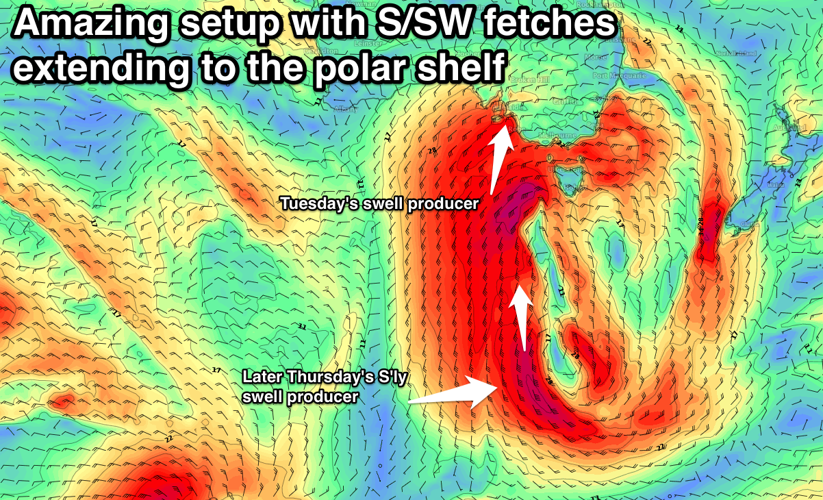
Tuesday morning looks massive, with surf in the 8-10ft range across the South Coast, with a reinforcing large S/SW groundswell for the afternoon. This will be produced by an embedded fetch of severe-gale S/SW winds projecting up on an active sea state, through our southern swell window Monday.
Exposed breaks should continue in the 8ft+ range into the afternoon, easing from 6-8ft Wednesday morning.
The Mid Coast will remain large and messy Tuesday with easing sets from the 3-4ft range, smaller and 2ft Wednesday.
Now, winds Tuesday look to remain average and fresh to strong from the W/SW, similar but slightly weaker Wednesday. The chance for early W'ly winds around Victor early looks really slim at this stage, but we'll review this Monday.
Thursday looks like the best day to surf as winds swing back to the W/NW along with moderate to large amounts of S'ly swell from a stalling fetch of polar S'ly gales. We'll have a closer look at this Monday though. Have a great weekend!