Easing W/SW and S swell with improving conditions

South Australian Forecast by Craig Brokensha (issued Friday 18th August)
Best Days: Mid Coast Saturday, keen surfers South Coast from mid-late morning, South Coast Sunday morning, Tuesday morning
Recap
A slight drop in size across the Mid Coast yesterday morning, back to a messy 3ft, while stormy waves kicked back into the afternoon with a strengthening onshore wind.
The South Coast was good and clean in protected spots yesterday morning with 3ft sets off Middleton, a little bigger into the afternoon.
Today stormy 3-4ft surf is continuing across the Mid with strong SW winds, while the South Coast offered plenty of size again but with less than ideal W'ly winds.
We should see a strong S'ly swell building through this afternoon across the South Coast but winds will be onshore by then.
This weekend and next week (Aug 19- 25)
Satellite observations of the S'ly fetch generating later today's S'ly swell for the South Coast are great, with 35-45kt winds registered.
This swell is expected to peak overnight but tomorrow morning we should still see 3-4ft sets across Middleton and other spots usually protected from west swells, while the Mid Coast will see today's W/SW swell easing back from 2-3ft.
Winds will be best for the Mid Coast with a dawn S/SW'ly expected to ease and tend lighter S/SE through the day. So the morning surf probably won't be the best. The South Coast will unfortunately be onshore all day, but only light so conditions should improve through the day as well.
 Come Sunday the W/SW swell will be fading from 1-1.5ft max on the Mid, while the South Coast is due to be small as well with easing 2ft+ waves off Middleton. You'll have to get in during the morning down South as a fresh NE tending N/NE will really strengthen into the afternoon linked to a strong mid-latitude low approaching from the west.
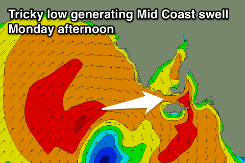
The models are still divergent on the position of the low, with it being too far north for the South Coast, but it may also form too far north for the Mid Coast.
Latest updates have a fetch of strong to gale-force W/SW winds just moving within the Mid Coast's swell window Sunday night and early Monday morning.
This should generate a spike of W/SW swell for the afternoon to 2-3ft on the Mid Coast, with a NW windswell through the morning to 1-2ft. Strong NW tending weaker SW winds will create average conditions, while the South Coast will be small to tiny and not worth it in the morning, with a poor windswell into the afternoon.
Into Tuesday winds will revert back to the W/NW creating cleaner conditions down South, with a mix of easing SW windswell and building SW groundswells.
The groundswell energy isn't significant and our models are incorrectly combining the windswell with it and over-forecasting the size. I wouldn't expect anything over 2-3ft across Middleton at this stage, and the Mid Coast will drop from a messy 2ft.
A better mix of long-period and inconsistent SW groundswell are expected on Wednesday, with the long-range energy being produced by a strong polar front in the Heard Island region. The short-range energy is expected from the remnants of the storm projecting up and towards us Sunday and Monday, with 3ft+ sets due off Middleton, 1-1.5ft waves on the Mid, but with what looks to be an onshore change. More on this Monday. Have a great weekend!