Fun S'ly swells for the South Coast ahead of W'ly swells

South Australian Forecast by Craig Brokensha (issued Wednesday 19th July)
Best Days: South Coast tomorrow and Friday, South Coast Sunday afternoon and both coasts Monday
Recap
Large stormy waves in the 3-4ft range across the Mid Coast yesterday. Easing back to a bumpy but more workable 2ft to occasionally 3ft with lighter S'ly winds this morning.
The South Coast was clean in protected spots with an inconsistent 2-3ft of swell off Middleton through the morning, increasing a bit into the afternoon but with stronger W'ly winds.
A strong onshore change moved through yesterday evening and this has whipped up a poor quality windswell across the coast this morning.
This week and weekend (Jul 20 – 23)
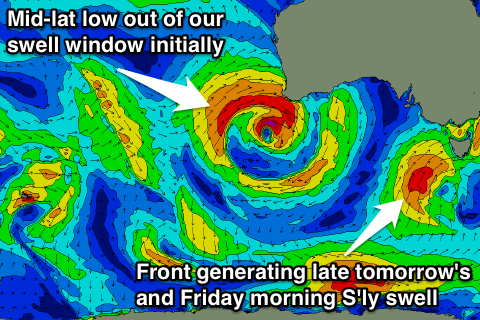
The mid-latitude low responsible for the stormy waves on the Mid Coast yesterday and South Coast today is currently pushing further east and with this we'll see the swell ease off out of the S'th later today across the South Coast, further tomorrow.
A polar front projecting up through our southern swell window from the polar shelf will generate a new mid-period S'ly swell for later in the day tomorrow, but more so Friday morning.
 We should see Middleton easing from 3ft+ across most spots tomorrow morning (possibly kicking back late to this size), while the Mid Coast is due to be tiny with fading 1ft+ sets.
Conditions will improve rapidly as a ridge of high pressure moves in from the west, resulting in variable winds across both coasts all day.
Friday's S'ly swell pulse should keep most breaks coming in at 3ft+ again, easing through the day under fresh N/NE tending N/NW winds. The Mid Coast will be tiny and bumpy.
Into the weekend we'll see some tricky W'ly swell filling in. This will light up the Mid Coast more than the South Coast, with the mid-latitude storms sitting too north and mainly out of its swell window.
Currently an intense mid-latitude low is sitting off WA, out of our swell window, but this system is due to weaken and then push slowly east while generating a fetch of strong W/SW winds under WA towards the Bight tomorrow afternoon and evening.
A small pulse of W'ly swell is due from this fetch on Saturday afternoon, pulsing to 2ft on the Mid Coast, while the South Coast is likely to be tiny, possibly increasing to 1-2ft through the afternoon.
Fresh NW tending weaker W/NW winds will create less than ideal conditions for the Mid, while the South Coast will be clean but not worth the drive from Adelaide.
A secondary slightly stronger mid-latitude front pushing towards and under WA on Friday should generate a larger W/SW groundswell for Sunday afternoon.
We should see the Mid Coast building from 2ft during the morning to 2-3ft into the afternoon but with moderate to fresh W'ly winds.
The South Coast should also kick a little with small 2ft waves through the morning at Middleton, bigger to 2-3ft into the afternoon.
Our models are incorrectly combining some small inconsistent long-period groundswell with this new westerly swell and over-forecasting the size.
Come Monday the W/SW swell should ease back from 2ft on the Mid Coast and a similar size across Middleton with light offshore winds across the South Coast (likely light N on the Mid). We'll confirm this Friday.