Great waves over the weekend, stormy next week
South Australian Forecast by Craig Brokensha (issued Friday 14th July)
Best Days: Both coasts Saturday morning, South Coast Sunday and Monday, stormy haunts on the Mid Monday and Tuesday morning
Recap
Tiny windswell waves yesterday, building a touch through the day with strengthening N'ly winds, while the South Coast was small to tiny all day.
Today a good new SW groundswell has filled in across the South Coast with 3ft waves off Middleton with morning W/NW winds, but onshores have since moved in, while the Mid Coast was an average bumpy 2ft this morning, but an increase in stronger groundswell and windswell have since been seen with sets to 3ft.
This weekend and next week (Jul 15 – 21)
Today's onshore change is linked to the remnants of a vigorous polar frontal progression that developed earlier this week between Heard Island and Western Australia.
A broad fetch of severe-gale W/SW winds were projected towards WA and through our western swell window, producing a moderate to large long-period W/SW groundswell.
This groundswell should fill in later today and peak tomorrow morning. The remnants of the storm continued to generate a good strong fetch of W/SW winds through our swell window the last couple of days, producing some good reinforcing mid-period W/SW swell for tomorrow afternoon.
We should see the South Coast coming in around a solid 4-5ft off Middleton, easing slightly through the day and then down from the 3ft range Sunday morning.
The Mid Coast should see good 2-3ft sets tomorrow, easing back from 1-2ft Sunday.
Winds are looking great for both coasts tomorrow with today's change moving off to the east leaving variable tending light offshore winds, NW into the afternoon.
Sunday will then be best down South with a strengthening N/NE tending N/NW breeze (kicking up an afternoon increase in NW windswell on the Mid Coast).
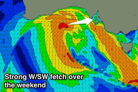
This strengthening NW'ly will be related to a vigorous mid-latitude low moving in from the west with the system being favourably aligned for the Mid Coast, but a little too north for the South Coast.
We'll see this low generating a fetch of strong W/SW winds through our western swell window tomorrow and Sunday, likely stalling south-west of us Monday while continuing to generate a strong fetch of W/SW winds. The low should move slowly east through Tuesday, with the South Coast seeing a strong fetch of S'ly winds projected up and into it.
 What we can expect is a large stormy W/SW swell for Monday across the Mid Coast, coming in at 3ft, with 4ft sets developing into the afternoon along with strengthening W/NW winds.
Protected spots down South should remain clean but early the surf only looks to be around 2ft off Middleton, building more to 3ft through the afternoon.
A touch more size is expected into Tuesday before a large stormy S'ly swell is seen Wednesday.
The Mid Coast should ease back from a stormy 3ft to maybe 4ft Tuesday morning, small into Wednesday when winds go more S'th.
We'll have to have another look at this low on Monday though, as the models are still trying to resolve its exact movements, so check back then for an update. Have a great weekend!

