Good conditions and swells for the South Coast

South Australian Forecast by Craig Brokensha (issued Wednesday 5th July)
Best Days: South Coast Thursday, Saturday morning, Sunday, Monday
Recap
Easing semi-stormy waves from the 2ft range across the Mid Coast yesterday morning with fresh and gusty onshore winds. While the South Coast was OK in protected spots with an inconsistent easing swell from Monday.
Today the swell has remained small across the South Coast with tiny sloppy and onshore 1-1.5ft waves on the Mid. A new long-period SW groundswell has been picked up by the Cape du Couedic wave buoy, but no major size is due until later this afternoon.
We should see Middleton coming in at 3ft on the sets with light onshore winds, worth a surf.
This week and weekend (Jul 6 - 9)
This afternoon's building long-period and inconsistent SW groundswell is due to peak tomorrow morning to a good 3-4ft across Middleton before easing off into the afternoon, further from the 2ft Friday morning.
The Mid Coast will see a mix of easing W/SW windswell and inconsistent groundswell to 1ft+ max.
Conditions tomorrow are looking excellent with a fresh N/NE tending N/NW breeze down South, while an intense mid-latitude low moving in from the west for Friday looks to only clip us with light W/NW tending fresh to strong W/SW winds developing through the day.
This low is currently in the form of a cold front pushing across WA, with it generating a W/SW groundswell for Friday afternoon and Saturday morning. This will be over-shadowed by a building semi-stormy swell into the afternoon as the mid-latitude low pushes in from the Bight.
 No size is due early, but we should see 2ft to nearly 3ft waves developing by dark on the Mid Coast with fresh to strong W/SW Winds.
The mid-latitude low will weaken overnight Friday leaving NW winds across both coasts and easing levels of swell Saturday. The Mid Coast should ease back from a bumpy 2ft with the South Coast seeing an inconsistent long-range swell keeping 2-3ft sets hitting Middleton.
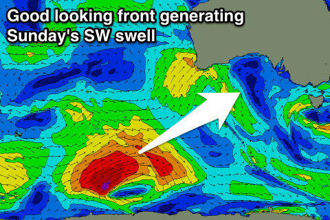
Into Sunday we've got a great new SW groundswell due across the South Coast, produced by a strong polar frontal system that's currently east of Heard Island. A pre-frontal fetch of W/NW gales have produced a small active sea state for a better aligned and stronger fetch of W/SW gales to move over, projecting east-northeast towards us before weakening south of WA tomorrow afternoon.
With an upgrade in strength from Monday we can now expect good 4ft sets across Middleton Sunday when it peaks and winds look great, holding from the W/NW all day, favouring protected spots.
The Mid Coast will see small levels of W/SW windswell persisting from trailing fetches of W/SW winds from the backside of the low moving through Friday. 1-2ft sets are due but with that onshore westerly wind.
The surf should ease a touch into Monday morning with NW winds creating clean conditions again down South. A new swell is possible into the afternoon from a relatively weak frontal progression moving in late on the weekend, but more on this Friday.