Swell and offshore winds continue
South Australian Forecast by Craig Brokensha (issued Wednesday 11th June)
Best Days: Every day South Coast (earlier rather than later Saturday), Mid Coast Thursday afternoon and Friday
Recap
A little pulse of W/SW swell to a glassy 1-1.5ft across the Mid Coast yesterday, while the South Coast saw clean fun waves most of the day, best through the morning around the low tide.
Today conditions were perfect down South with the swell hanging in around the fun size range, while the Mid was back to a bumpy 0.5-1ft.
The long-period forerunners from a strong but inconsistent SW groundswell have hit the Cape du Couedic wave buoy this morning, coming in at 22.3s and we should see some size start to show later this afternoon across both coasts as winds hold from the N/NW.
This week and weekend (Jun 15 – 18)
There's been no real change to the inconsistent SW groundswell event that will fill in later today and peak tomorrow morning, followed by a solid reinforcing W/SW swell into the afternoon.
Middleton should see inconsistent 4-5ft sets but with waits of up to 10 minutes between then, while the Mid Coast is only due to be around 1-2ft through the morning, pulsing to 2ft+ with the new more consistent W/SW swell into the afternoon.
Into Friday both swells should ease off, slowed by some reinforcing SW swell from a good fetch of pre-frontal W/NW gales passing under WA and the Bight today.
 Middleton should ease from 4ft on the sets Friday morning, back from 3ft Saturday while the Mid is expected to ease back from 2ft.
Conditions will be excellent down South through this period with straight offshore N/NW tending variable winds Thursday and Friday, more variable Saturday before giving into a shallow SW change. The Mid should see light N/NE winds early each morning creating clean conditions with those variable breezes into the afternoon.
Now into Sunday we've got three separate new groundswells filling in all at once, and while this sounds great, in the surf zone there's likely to be annoying double-ups with close spaced waves ruining each other.
The first swell will be from the SW, generated by a stronger fetch of pre-frontal W/NW winds moving in under WA and south of the Bight tomorrow. This should generate a pulse in size for Sunday morning, likely to 3ft off Middleton, but not much above 1ft+ on the Mid Coast.
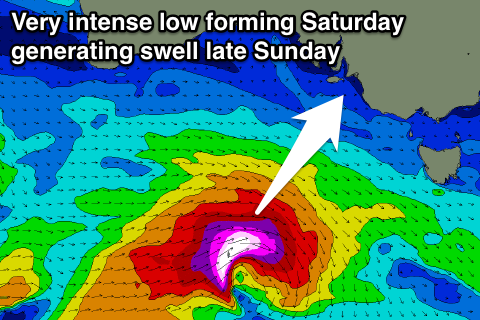
Trailing this W/NW fetch will be a polar fetch of gale to severe-gale W'ly winds, producing a stronger S/SW groundswell for the afternoon, likely to 3-5ft, but even more significant is a very strong mid-latitude low that's forecast to form south of the Bight Friday evening.
This low will deepen significantly in our southern swell window, producing a burst of storm-force W/SW winds in our swell window Saturday, generating the third moderate to large S/SW groundswell for later Sunday, pulsing to 5ft+ across Middleton but having no impact on the Mid.
Winds on Sunday look to swing back offshore for the South Coast through the morning with weak sea breezes, while early next week looks great as the swells ease under offshore winds. More on this Friday.

