Excellent period of surf for South Oz

South Australian Surf Forecast by Ben Matson (issued Wednesday 31st May)
Best Days: Plenty of fun small waves on the Mid Coast most days, looking best Sunday. Clean surf at Victor from Thurs to Sun or maybe early Mon.
Recap: Onshore winds created messy conditions at Victor Tuesday but remained light enough on the Mid to allow for reasonable surf, as a new groundswell built across the coast. This swell peaked early this morning around 2ft+ across the Mid and 3-5ft at Victor, with light offshore winds across both coasts. Surf size is now slowly easing.

Early Wednesday sets at South Port
This week (Jun 1 - 2)
Thursday morning will see an initial decreasing trend from today, and light NNE winds will keep conditions clean across both coasts. The Mid Coast should still manage inconsistent 1.5ft sets at times, with Victor more likely to be around the 3ft mark at Middleton (bigger at Waits, Parsons and Goolwa as per usual), easing during the morning.
Some time around mid-late morning, the leading edge of a new long range W/SW groundswell is expected to reach the mainland - look for a jump at the CdC buoy to 16-17 seconds - generated by a cut-off low that formed west of Margaret River earlier this week. This system didn’t track especially favourably through our swell window but the pre-frontal fetch was impressive and it’s common for the South Oz coast to receive small, useful waves from these kinds of systems.
The swell should start to build into the afternoon, reinforcing the existing (though decaying) Mid Coast swell to 1-2ft, possibly nudging slightly higher if we’re really lucky right on dark. At Victor Harbor, the strong W component in the swell will keep wave heights a little below par but Middleton should rebound back into the 2-3ft mark by late in the day.
Thursday’s afternoon’s pulse should hold overnight into early Friday morning but will ease slowly in size during the day, with continuing light winds from the NE maintaining clean conditions across all coasts.
This weekend (Jun 3 - 4)
We’ve got some great waves ahead this weekend, and the good news is that winds are expected to remain light both days.
Saturday will for the most part see easing swells from Friday, under a light N/NE breeze. Inconsistent 1-2ft sets are possible across the Mid Coast though they’ll be very tidally dependent. Middleton should see occasional 2-3ft waves with bigger surf at exposed coasts.
Late afternoon, the leading edge of a new series of long range W/SW swells are expected to reach the coast. I’m doubtful that we’ll see an appreciate kick before sundown but it’s possible across the Mid Coast.
Nevertheless, Sunday is looking at the first of several long period groundswells producing good waves across the Mid Coast. These swells will be generated by a broad, vigorous series of intense cold fronts and lows south of WA over the coming days. I’m not expecting a peak in size until later Monday or Tuesday so there’ll be no need to rush on Sunday as the trend will be slowly upwards all day.
The Mid Coast should start off around 1-2ft but by late afternoon we should be seeing occasional 2-3ft sets, clean with mainly light winds. At Victor, the strong westerly component in the swell direction won’t assist surf height but Middleton should also increase into the 3ft+ range by the end of the day, with bigger surf elsewhere.
Let’s fine tune the specifics on Friday. But at this stage the weekend’s looking pretty good all ‘round.
Next week (Jun 5 onwards)
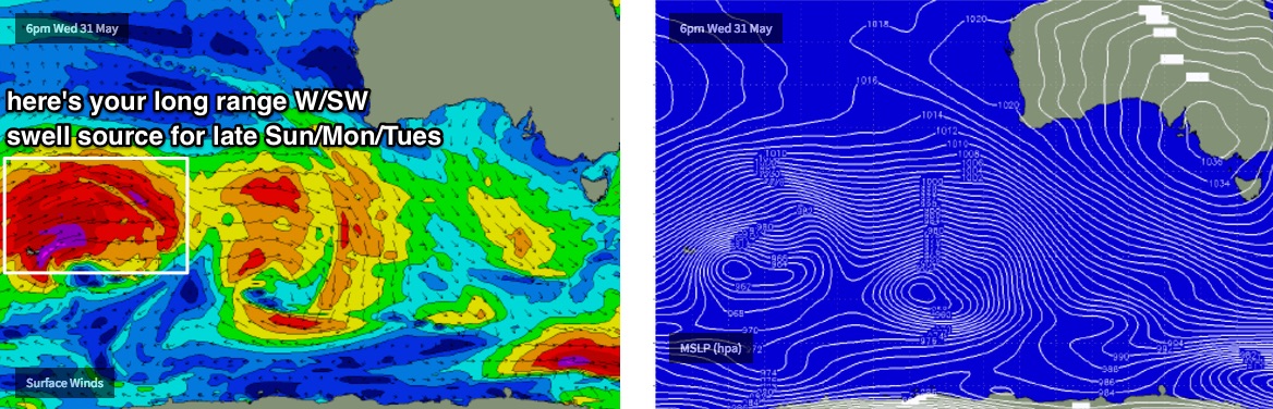
Monday and Tuesday will see a broad plateau in size from this long range series of weather systems. Unfortunately, a cold front is expected to cross the coast around the same time and in doing so will rapidly deteriorate surface conditions.
As such there’s not much point going into detail about the swell’s specifics when conditions could possibly be quite ordinary on the surface, associated with a polar outbreak - and therefore very cold air temps. In fact the models are quite divergent too (the US solution suggesting unseasonable SE or even E'ly winds Tues/Wed next week, which is rather unlikely IMO).
I’ll review on Friday in the event conditions are more consolidated across the models - the polar outbreak is very likely but the exact position (and thus, local winds) is still some time away from being certain. But the main points are plenty of west in the swell direction (ideal for the Mid) and a broad peak in size over the space of three days (Sun to Tues at least). The groundswell component from this source could produce 3ft+ sets in the gulf around Monday or Tuesday.
Looking beyond this and the Southern Ocean storm track is expected to remain quite active into the long term period, favouring an extended run of strong, sizeable groundswells across the SA coast throughout the second half of next week and the following weekend. More on this in Friday’s notes.
Comments
Nice lines at South Port again this AM!
One bloke has the lineup to himself (he's fanging along this wave).
Gone to almost flat this morning . 2-3ft lines of swell incoming here.