Improving winds and small swells from Friday, large surf next week

South Australian Forecast by Craig Brokensha (issued Wednesday 22nd March)
Best Days: Friday/Saturday/Sunday/Monday mornings down South, later Sunday for tiny Mid Coast waves, Tuesday morning both coasts
Recap
Fun easing 1-2ft waves across the Mid Coast yesterday, while today we were back to tiny conditions.
The South Coast was poor with fresh onshore winds and a building windswell, although there was a small window of cleaner conditions as winds eased mid-afternoon.
Today the coast was solid with a junky windswell and strong onshore winds.
This week and weekend (Mar 23 – 26)
Later today we're due to see a good new S/SW groundswell across the South Coast, peaking tomorrow morning, produced by a strong polar low over the weekend and Monday.
This swell should be slightly larger than the S/SE windswell generated by these persistent S/SE winds, with 3ft+ sets across Middleton. Conditions will remain poor though with a fresh and gusty SE wind (possibly E/SE for a period) but this won't improve conditions.
Friday morning is still looking fun as winds tend NE and we see a peaky mix of easing S/SW and S/SE swells to 2ft+ off Middleton and 3-4ft at Waits and Parsons.
The Mid Coast will remain tiny to flat through this period.
Into the weekend, two small pulses of SW groundswell are due, along with light winds and clean conditions each morning.
These swells were produced by less than favourably aligned but strong pre-frontal W/NW fetches south-southwest of WA.
The first swell for Saturday looks to come in around an inconsistent 2ft across Middleton, with Sunday's seeing a touch more size to 2ft+. Waits and Parsons will be bigger and better. The Mid Coast will fail to see any size.
A variable wind should create good conditions Saturday morning ahead of sea breezes, while Sunday will be a little straighter with a light N/NE'ly through the morning.
 Into Sunday afternoon a very inconsistent W/SW groundswell is due, generated by a vigorous but distant polar frontal progression through the Indian Ocean earlier this week.
Very inconsistent 3ft sets are due to develop across Middleton, with 1-1.5ft sets on the Mid Coast through the afternoon/evening with weak afternoon sea breezes not doing too much damage.
Next week onwards (Mar 27 onwards)
Sunday afternoon's inconsistent groundswell should ease back slowly through Monday from 2-3ft off Middleton and 1-1.5ft on the Mid, and an early N'ly wind should create clean conditions before a fresh to strong W/SW change moves through.
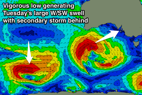
This change will be linked to a vigorous mid-latitude low racing through the Bight towards us, under the influence of a strong node of the Long Wave Trough.
An increase in W/SW windswell should be seen on the Mid, while of greater significance is the large W/SW groundswell due of the earlier stages of the low.
The Long Wave Trough will strengthen while approaching from the west early next week, directing a series of vigorous frontal systems up through our western swell window.
The first of these will be the low mentioned above, with a fetch of gale to severe-gale W/SW winds due to develop south-west of WA, projecting east through the Bight towards us Sunday through Monday.
A large and powerful W/SW groundswell will be generated, peaking Tuesday to a solid 3-4ft on the Mid Coast, 4-5ft+ at Middleton and much larger at Waits and Parsons.
We may see variable winds in the wake of Monday's change owing to another strong front approaching from the west, followed by a secondary large W/SW groundswell Thursday, but more on this Friday.