Great Wednesday, pumping Mid late Thursday/Friday

South Australian Forecast by Craig Brokensha (issued Monday 13th March)
Best Days: South Coast Wednesday, Mid Coast later Thursday and Friday, South Coast Saturday through Monday morning
Recap
A fun day at swell magnets Saturday morning with a small clean swell, while Sunday was tiny and clean again early.
The Mid Coast was tiny Saturday while some solid windswell whipped up through the day with an approaching low.
This morning the windswell was back to 1-1.5ft on the Mid with cleaner conditions and lighter winds, while the South Coast was a sloppy mess.
This week and weekend (Mar 14 – 19)
Tomorrow morning will be clean with a light offshore wind down South but there's not due to be much swell at all in the water.
Later in the day though a strong new SW groundswell is due, peaking Wednesday morning.
This swell was generated by a distant but strong polar low late last week and over the weekend, with a late kick in size due to 3ft at Middleton tomorrow, with Wednesday morning seeing 3ft to nearly 4ft waves at dawn. A steady easing trend is due through the day, further Thursday.
The Mid Coast isn't due to see any size at all above 0.5-1ft max.
 Conditions Wednesday are looking excellent all day down South with a moderate to fresh N/NE'ly, easing and tending more variable from the NW into the late afternoon evening.
This will be ahead of an approaching but weakening low, bringing gusty onshore SW winds Thursday morning and an increase in windswell across the Mid Coast to 2ft.
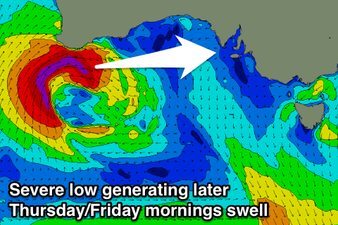
Of greater importance though is the W/SW groundswell due from the early stages of the low today. We're seeing a strengthening fetch of severe-gale SW winds projected towards WA, on the edge of our western swell window and this should produce an acute W/SW groundswell for us that may be seen later Thursday, peaking Friday morning.
The Mid Coast will see the bulk of this energy with solid 3ft surf due Friday (if not later Thursday), with the odd bigger one possibly in the mix.
The good thing about later Thursday and Friday is that a high pressure system is due to move in quickly, swinging winds back to the S/SE late in the day, with offshore E/SE winds Friday morning, creating excellent conditions.
The South Coast won't see much size from this west swell with 2-3ft sets off Middleton along with those poor winds.
Easing surf is due into the weekend, but a little reinforcing SW swell is expected to slow the trend, generated by a weak mid-latitude front passing under the country.
The Mid Coast should see 1-2ft waves all day, with easing 2-3ft sets at Middleton along with a NE offshore wind.
Sunday will be super clean but smaller again.
Now, later Sunday and more so Monday another strong long-period W/SW groundswell is expected across the state, generated by a vigorous polar frontal system in our far swell window, firing up towards WA.
This swell looks to be met with offshore N'ly winds ahead of an onshore change, but more on this Wednesday.