Small ahead of a good W'ly swell Sunday

South Australian Forecast by Craig Brokensha (issued Wednesday 4th January)
Sign up to Swellnet’s newsletter and receive the South Australian Forecaster Notes and latest news sent directly to your inbox. Upon signup you'll also enter the draw to win a surf trip to P-Pass for you and a mate. It doesn’t get much easier so click HERE to sign up now.
Best Days: South Coast Friday morning, South Coast Saturday morning, Mid Coast Sunday afternoon and Monday
Recap
Tiny waves on the Mid Cast yesterday, pulsing a little through the afternoon, while the South Coast has been very average with a sloppy 2-3ft of S/SE windswell and background SW groundswell.
This week and weekend (Jan 5 - 8)
Poor conditions will continue across the South Coast tomorrow with a fresh SE tending S/SE breeze and sloppy S/SE windswell in the 3ft range,
Friday morning however should see winds swinging light offshore from the N/NE with easing 2-3ft sets across most exposed breaks.
We'll likely see winds tend variable into the early/imd afternoon before sea breezes try and kick in late, but the swell will be small by then. The Mid Coast is due to be tiny to flat through the end of the week.
Our new S/SW groundswell due Saturday morning is still on track with a relatively weak polar front currently generating a fetch of strong to gale-force W'ly winds through our southern swell window.
We should see the swell building later Friday and peaking Saturday morning to a small 2ft at Middleton and 2-3ft at Waits and Parsons.
Good conditions are due most of the day with a hot offshore N/NE tending N/NW breeze ahead of a late onshore change, likely around dinner.
This change will be linked to a weakening mid-latitude moving in from the west, and this low will generate an acute W'ly swell for the Mid Coast Sunday.
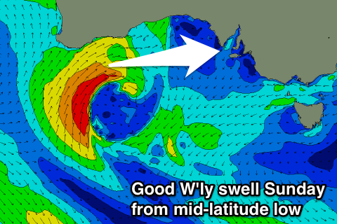 The low will form off WA's South West tomorrow evening, moving slowly east through the Bight while generating a weakening fetch of strong to gale-force W/SW winds.
A moderate sized W/SW groundswell should fill in on the Mid Coast Sunday, building to a good 2-3ft through the afternoon. The swell will be too west for the South Coast, with tiny waves through the morning, increasing very slightly through the afternoon.
Winds on Sunday look to be from the W through the morning, giving into S/SW sea breezes and then swinging S/SE late across the Mid Coast.
Monday will be clean as the swell eases from 2ft on the Mid Coast under a SE breeze.
Longer term some further small pulses of W/SW groundswell are due Tuesday/Wednesday but a stronger and slow moving polar front should generate a moderate sized SW groundswell for later Wednesday and Thursday. Unfortunately winds are this stage look poor and from the S'th, but more on this Friday.