Good run of swell for the South Coast, cleanest from Wednesday

South Australian Forecast by Craig Brokensha (issued Monday 3rd September)
Best Days: South Coast protected spots Tuesday morning, South Coast Wednesday through Friday, South Coast Sunday morning
Recap
Great waves down South Saturday as an offshore wind cleaned up an easing S/SW swell with good sized waves across all locations during the morning. A steady drop in size was seen, with small leftovers Sunday morning.
The Mid Coast was bumpy and tiny Saturday, with a building windswell through Sunday afternoon.
Today large stormy 3-4ft waves were seen due to a mix of new groundswell and windswell.
As expected the swell is very west for Victor, but on the build with strong W'ly winds, leaving protected locations with the best but marginal conditions.
This week (Oct 4 - 7)
A vigorous front moving through the Bight is linked to today's building mix of swells and these should peak tomorrow morning.
Another front pushing through overnight and tomorrow morning should generate an additional W/SW swell for tomorrow afternoon, easing back through Wednesday.
Middleton should see 3-4ft sets, possibly a touch bigger tomorrow afternoon with the Mid Coast continuing around a stormy 3-4ft.
Winds will be fresh to strong from the W/NW, tending W/SW late morning, leaving protected locations on the South Coast with the best conditions.
Winds will ease and swing offshore from the NW Wednesday morning, tending back to the W/NW through the middle of the day, but also easing on the Mid. This should create improving conditions with easing 2-3ft sets.
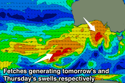 Into Thursday a mix of medium-range and close-range SW swells are due across the state.
This medium-range energy has and is still being generated by a polar front on the tail of the progression pushing through the Bight, with the close-range energy generated by a late forming mid-latitude low to our south on Wednesday.
The swell is more favourably aligned for the South Coast than the Mid, with 3-4ft sets due to continue off Middleton, easing later in the day and further Friday. The Mid Coast should offer 1-2ft sets, fading through the day.
A further improvement in winds should be seen Thursday with an all day offshore N/NW breeze. The Mid will be bumpy even with an early N'ly breeze.
As the surf eases Friday, NW tending W/NW winds are due down South ahead of a late onshore change.
This weekend onwards (Oct 8 onwards)
A small lift in new SW groundswell is due Saturday morning from a tight, intense but south-east drifting mid-latitude low under the country late week. This won't be favourably aligned but the core wind speeds to the storm-force range should help kick up a swell to 2-3ft or so off Middleton and 4ft+ at Waits and Parsons, easing through the day.
Conditions look average though with easterly breezes, cleaner Sunday as the swell eases. The Mid will be clean but tiny.