Less than ideal weekend, fun days next week ahead of large swell

South Australian Forecast by Craig Brokensha (issued Friday 23rd September)
Best Days: Saturday morning swell magnets South Coast, Sunday morning protected spots South Coast, Monday morning South Coast, Tuesday both coasts
Recap
Terrible conditions across the South Coast yesterday with a strong but easing onshore wind, while the Mid Coast saw workable 1-1.5ft sets.
Today the South Coast was much better and best at Waits and Parsons with a smaller swell and offshore wind. The Mid Coast was tiny and lumpy.
This weekend (Sep 24 - 25)
There won't be much left in the tank for tomorrow morning with a morning offshore N'l tending N/NW breeze ahead of a W/SW change early-mid afternoon. Waits and Parsons may still have 2-3ft sets early, but you'd have to be keen. The Mid Coast will be tiny.
Into the afternoon a new long-range W/SW groundswell should be seen, but winds will be onshore across both coasts, and Sunday will be a better chance for this.
The swell was generated earlier this week by a strong mid-latitude front moving through the south-east Indian Ocean, and should offer inconsistent 2ft sets on the favourable parts of the tide along the Mid with inconsistent 3ft waves at Middleton. Winds look average now with a fresh and easing W/SW breeze on the Mid, and W/NW tending W/SW breezes down South. Protected spots will be OK through the morning.
Next week onwards (Sep 26 onwards)
Sunday's swell should ease through Monday and conditions will be best through the morning with a NW offshore down South ahead of a W/SW change during the afternoon. The Mid will be bumpy and around 1-2ft most of the day.
 A good new pulse of SW groundswell is due into Tuesday afternoon, produced by a strong polar low currently firing up to the south-west of WA. This low will project a fetch of strong to gale-force SW winds towards us with a good SW groundswell resulting.
This swell is expected to reach 3ft across Middleton with 1-2ft sets on the Mid Coast. A light NW tending W/NW breeze is due down South, while more variable breezes are expected across the Mid, creating clean conditions.
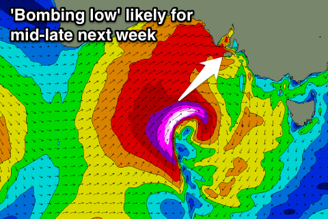
A slight drop in size is due Wednesday morning ahead of a new SW groundswell pulse later in the day and more so for Thursday morning. This will be superseded by a much larger SW groundswell Thursday afternoon and Friday morning as a vigorous mid-latitude low develops in the Bight, most likely 'bombing'.
That being dropping more than 24hPa in less than 24 hours.
This should result in a fetch of storm-force SW winds developing right on our doorstep, generating a large increase in W/SW and SW groundswell for Thursday/Friday. We'll have a closer look at this on Monday. Have a great weekend!