Back to back swells pulses, cleanest down South

South Australian Forecast by Craig Brokensha (issued Monday 9th May)
Best Days: South Coast from Wednesday
Recap
Great waves across both coasts Saturday, with the South Coast being the standout with a new building SW swell and offshore winds (the Mid clean but small).
A drop in size was seen through Sunday with tiny leftovers on the Mid, while the South Coast offered fun clean conditions all day.
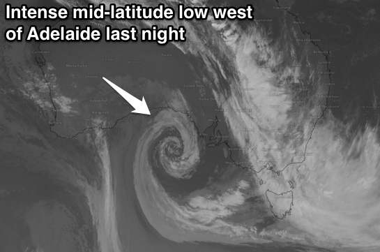 Today a vigorous and amazing looking mid-latitude low is currently pushing in towards us, with Neptune Islands registering gusts of up to 59kts (109km/h).
This is kicking up stormy increase in NW windswell across the Mid, while the South Coast was clean and small early, but average now with the strong offshore (50kt at Hindmarsh Island).
This week and weekend (May 10 - 15)
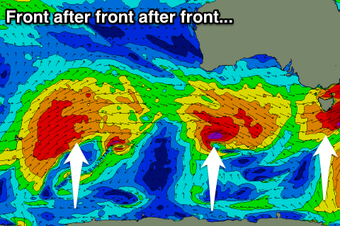
South Coast: We've got a very active period ahead across the state as the westerly storm track becomes overactive through this week and next.
This will see front after front after front projecting through our swell window, with persistent north-west to westerly winds, favouring the South Coast over the Mid.
Currently the intense mid-latitude low is moving across us, and with this we'll see a fetch of gale to severe-gale SW winds moving across us later this afternoon and evening.
A building short-range SW swell is due through tomorrow, reaching a messy 4-5ft across Middleton through the day but with poor and strong SW tending W/SW winds.
This swell will ease into Wednesday but only to be replaced by a new S/SW swell from a strengthening polar front pushing up from the south-west and joining with the low tomorrow.
This should build through the day and reach 3-5ft across Middleton, larger at Waits and Parsons.
 Conditions will be cleaner as well with a fresh W/NW'ly due to another approaching front, while with this front we'll see another SW groundswell pulse for Thursday.
Solid 4-5ft sets are due across Middleton most of the day as W/NW tending NW winds continue to keep protected locations clean.
Friday morning should reveal similar sized waves before easing off slowly into the afternoon as NW tending N/NW winds continue to create clean conditions.
Yet another vigorous front moving east will generate a fetch of severe-gale W/SW winds through our south-western swell window Thursday and Friday, producing a good SW groundswell for Saturday morning.
This pulse should again provide 4-5ft waves across Middleton with larger sets at Waits and Parsons under offshore and fresh N/NW breezes, giving into a late SW change.
Further on the frontal activity will continue through the weekend and into early next week, but more north in latitude, producing swells more from the W/SW than SW, but we'll have a closer look at this Wednesday.
Mid Coast: Currently a stormy NW windswell is developing across the Mid and this will swing more W/SW and then SW into tomorrow with the change in wind direction from the mid-latitude low as it moves across us.
Stormy and easing 2-3ft sets are due tomorrow morning, easing into the afternoon, with Wednesday coming in around the messy 2ft range, continuing around a bumpy 2ft on the sets Thursday. 1-2ft waves are due to continue Friday with Saturday holding the same size due to the SW direction of the swells.
From later Sunday and most so next week is when we'll see some better sized W/SW groundswell energy, but more on this Wednesday.
Comments
South Port gone... Photo Boyd Kalimba