South Coast best Friday morning, fun small Mid swell Sunday arvo

South Australian Forecast (issued Wednesday 9th March)
Best Days: Keen surfers South Coast tomorrow morning, more so Friday morning, Mid Coast Sunday afternoon and tiny peelers Monday morning
Recap
Light variable winds each morning across the South Coast with fun amounts of groundswell, while the Mid has ebbed and pulsed around the 1ft range, cleanest each morning.
This week and weekend (Mar 10 - 13)
South Coast: Easing levels of swell are due across the coast into this afternoon, bottoming out tomorrow morning ahead of a new kick in S/SW swell through the day, peaking overnight and then easing Friday.
This swell is being produced by a small intense mid-latitude low currently to our south, aiming a fetch of S/SW gales through our southern swell window.
Middleton should hover around 3ft all day tomorrow, with 4ft+ sets at Waits and Parsons, easing back from 2-3ft and 3-4ft respectively Friday morning.
Conditions tomorrow are looking a little dicey with a light to moderate E/SE breeze that may tend lighter E/NE, while Friday is looking better with more variable breezes ahead of S/SW change.
 The weekend is looking poor with small leftovers Saturday along with fresh and gusty S/SE winds, while a strong new long-period SW groundswell for Sunday will be spoilt by similar winds.
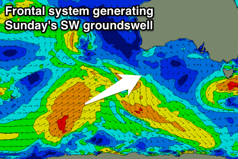
This groundswell started its life in our far far swell window to the south-west of Heard Island by a fetch of severe-gale W/NW winds. The polar low linked to this fetch has since moved east while continuing to produce a fetch of W'ly gales. The storm is now south-west of WA, and forecast to project north-east while weakening today and tomorrow, leaving a good SW groundswell to travel towards us.
The swell should arrive through Saturday evening and build to a peak through the day Sunday to a strong 3ft+ at Middleton and 5ft at Waits and Parsons. As touched on above though, conditions will be poor.
Mid Coast: The S/SW swell due across the South Coast tomorrow afternoon and Friday won't impact the Mid with tiny 0.5ft sets due, near flat into Saturday.
Sunday's SW groundswell is better though with the north-east projection of the swell producing front due to produce some fun sets waves to 1-2ft into the afternoon, more so on the incoming tide.
Next week onwards (Mar 14 onwards)
Sunday's strong SW groundswell will ease back through Monday across both coasts and the Mid will be the only option (but only to 1-1.5ft) with fresh to strong S/SE winds.
These S/SE winds will kick up moderate levels of S/SE windswell down South, persisting Tuesday along with the onshore winds.
Easing surf is then due into the middle of end of the week with lighter E/SE winds, but more on this Friday.