Light winds each morning and good pulses of swell

South Australian Forecast (issued Monday 7th March)
Best Days: Every morning across the South Coast this week
Recap
Tiny fading but clean 1ft waves across the Mid Coast Saturday even smaller into Sunday, with improving and OK waves for keen surfers Saturday morning down South, better Sunday with more variable winds and small fun 2ft waves at Middleton, with more size out at Waits and Parsons.
Today a new S/SW groundswell has filled in with glassy clean conditions down South and fun 2-3ft sets across Middleton, although a fresh onshore change has since moved through. The Mid remained tiny with the swell too south to make any real impact.
This week (Mar 8 - 11)
South Coast: Today's increase in S/SW groundswell will be superseded by a stronger pulse through tomorrow and Wednesday morning, generated by a vigorous and slow moving polar front the last few days.
This swell came in across WA today and over-performed a little, but I'm not going to change the forecast size due across our state, as Margaret River was much closer to the swell source compared to us.
The swell should kick through the day and reach a solid 4ft across Middleton into the afternoon with larger 5-6ft sets at Waits and Parsons, holding a similar size Wednesday morning before easing through the afternoon and further into Thursday morning.
Conditions tomorrow morning are looking favourable and probably improving through the morning as winds tend variable at dawn, allowing conditions to sort themselves out. Afternoon sea breezes are then due from early afternoon.
Wednesday looks to play out similarly with variable tending light offshore winds and afternoon sea breezes.
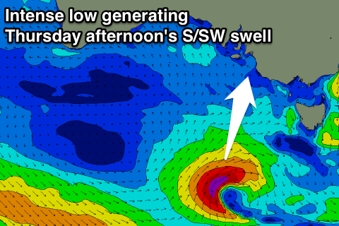 Thursday morning should again see light winds, more so from the E/NE, and a new S/SW groundswell is due to build through the afternoon, produced by a tight and intense mid-latitude low firing up south of the Bight tomorrow afternoon, aiming a fetch of S/SW gales through our southern swell window.
With the southerly aspect of the swell Middleton and Waits should see similar sized sets, building to 3ft+ into the afternoon/evening (more noticeably in the 3-4ft range at Waits) before easing from a slightly smaller range Friday morning.
Variable winds are on the cards again, but check back here Wednesday for the latest on this.
Mid Coast: Tomorrow's S/SW groundswell is due to perform the best out of the pulses due this week, building to an inconsistent 0.5-1ft before fading from a similar size Wednesday morning.
This weekend onwards (Mar 12 onwards)
Saturday is looking poor with no real decent swell left across the coast and fresher onshore S/SE breezes.
Into Sunday however a new long-range and inconsistent SW groundswell is due. This groundswell has already started to be generated in our far far swell window, south-west of Heard Island by an intense polar low. A fetch of gale to severe-gale W/NW winds are being generated, with the low due to travel east while continuing to generate a W/SW fetch, weakening while projecting slightly towards WA Thursday.
An inconsistent but moderate sized long-period SW groundswell will result, building Sunday and peaking through the day to a good 3-4ft along the Middleton stretch and 5ft at Waits and Parsons with E/SE breezes, but we'll have to look at this again Wednesday.