Average weekend, better next week

South Australian Forecast (issued Friday 4th March)
Best Days: Sunday morning exposed breaks for keen surfers down South, Monday morning, Tuesday and Wednesday mornings
Recap
A tiny start to the Mid yesterday ahead of a good new W/SW groundswell into the afternoon, offering 1-2ft sets as winds swung offshore into the evening. This swell has held this morning with cleaner conditions under straight offshore winds.
The South Coast started small, poor and onshore yesterday morning ahead of a late kick in size which has peaked this morning with variable breezes. Conditions have since deteriorated with a freshening onshore breeze and easing swell.
This weekend (Mar 5 - 6)
South Coast: This morning's swell will ease all weekend and conditions are looking poor tomorrow and OK if you keep your expectations low Sunday. Easing 2ft sets at Middleton and fresh SE winds make for poor conditions, while Sunday will be tiny and peaky around 1-1.5ft at Middleton, with 2ft+ waves at Waits and Parsons with a morning E/NE breeze before S/SE sea breezes kick in.
Mid Coast: Tiny 1ft sets are due tomorrow, ideal for beginners, with 0.5ft waves at best Sunday.
Next week onwards (Mar 7 onwards)
South Coast: As touched on Monday a flurry of strong polar frontal activity will generate a couple of good long-period S/SW groundswell pulses through next week.
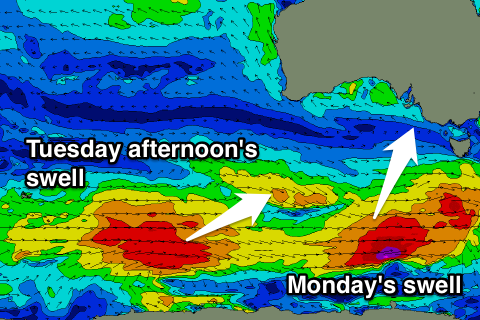 The first on Monday will be generated by a strengthening polar front developing south of WA today, producing a fetch of gale to severe-gale W'ly winds through our southern swell window.
A good new S/SW groundswell will be generated for Monday with 3ft sets across Middleton and bigger 3-5ft waves at Waits and Parsons.
Into Tuesday the swell will drop back temporarily ahead of a better new S/SW groundswell for the afternoon, easing Wednesday.
This slightly bigger swell will be generated by a secondary fetch of slower moving W'ly gales along the polar shelf.
Middleton should reach a stronger 4ft into Tuesday afternoon with 5-6ft sets at Waits and Parsons, easing from a slightly smaller size Wednesday morning.
Conditions on Monday are not the best with a morning E/NE breeze and peaky surf due, but Tuesday looks great with a N'ly offshore, tending NW ahead of a shallow afternoon change. Variable winds are then likely Wednesday morning ahead of afternoon sea breezes. We'll have another look at this Monday.
Mid Coast: The first S/SW swell will be too south in nature to influence the coast, but Tuesday and Wednesday's pulse will be a little better aligned, but again nothing more than 1ft+ is due. More on this Monday, have a great weekend!