Fun small Mid waves to end the week, better South Coast next week

South Australian Forecast (issued Wednesday 2nd March)
Best Days: Mid Coast tomorrow afternoon and Friday morning, keen surfers South Coast Friday morning, Saturday morning, Sunday morning swell magnets, Monday through Wednesday morning
Recap
Tiny Mid Coast waves yesterday and today with decent fun good 2-3ft sets easing across Middleton with offshore winds ahead of fresh sea breezes developing around midday.
Today the surf was again clean with a variable breeze down South and small fun waves at Waits and Parsons, tiny at Middleton.
This week and weekend (Mar 3 - 6)
South Coast: The next couple of days are poor with small weak windswell tomorrow morning along with moderate onshore SE winds, freshening through the afternoon from the S/SE.
Later in the day a new W/SW swell should show, produced by two successive mid-latitude fronts pushing under WA and through the Bight.
The first front was weakest and better aligned for the Mid, while the secondary front was stronger and better aligned for the South Coast.
While both swells are due to arrive around the same time, only a late kick in size is due down South tomorrow, peaking Friday morning to 3ft at Middleton and 4-5ft at Waits and Parsons.
Conditions will remain less than ideal Friday but will become more workable with a morning E/SE breeze (possibly tending E/NE if we're lucky) ahead of S/SE sea breezes.
Saturday will be cleaner as the swell eases from 2ft at Middleton and 3ft+ at Waits under morning NE breezes ahead of an afternoon S/SE'ly. Sunday morning will be clean again but small to tiny with fading 1ft+ sets at Middleton and 2ft waves at Waits and Parsons.
Mid Coast: Tomorrow should start tiny, but the first pulse of W/SW swell should building to a fun 1-2ft through the afternoon, easing from a similar size Friday and then becoming tiny through the weekend.
Next week onwards (Mar 7 onwards)
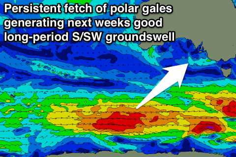 South Coast: From Monday next week we've got some good long-period S/SW groundswell energy due across the South Coast from a flurry of strong polar frontal activity.
The first and smallest pulse for Monday will be generated by a fetch of severe-gale W/NW winds south-east of Heard Island tomorrow, resulting in inconsistent 2ft waves at Middleton and 3ft+ sets at Waits and Parsons through the morning, building a touch more into the afternoon.
The best pulse due Tuesday will be produced by a better fetch of W'ly gales moving slowly east along the polar shelf through our southern swell window, arriving through Tuesday and building towards a peak into the afternoon/evening.
Middleton should offer good 3-4ft sets with 5ft+ waves at Waits and Parsons, easing from a similar size Wednesday morning. Clean conditions are due Monday morning again with N/NE offshores ahead of sea breezes, with more variable winds both Tuesday and Wednesday mornings. We'll have a closer look at this Friday though.
Mid Coast: No real decent size is due from the southerly swells with tiny 0.5ft waves Monday, possibly reaching 1ft Tuesday afternoon and Wednesday morning.