Fun couple of days, stronger swell from Friday afternoon

South Australian Forecast (issued Monday 22nd February)
Best Days: Tuesday and Wednesday mornings South Coast, Friday afternoon keen surfers both coasts, Saturday both coasts
Recap
Better conditions than expected on Saturday morning with winds tending more E/NE rather than E/SE with a good new pulse of swell and peaky conditions best suited to Parsons.
Sunday saw the swell ease back a touch under straighter offshore winds from the N/NE, creating cleaner conditions. The Mid Coast was clean but tiny to flat all weekend.
Today the surf remained tiny on the Mid, while the South Coast was the pick again with clean fun small surf, best suited to exposed breaks.
This week and weekend (Feb 23 - 28)
South Coast: The next couple of days are looking fun with two successive and similar sized pulses of SW groundswell due with morning offshores.
Middleton should hover between 2-3ft tomorrow and Wednesday with 4ft sets at Waits and Parsons, with NW tending SW winds tomorrow and N/NE to N/NW and then winds Wednesday ahead of a late onshore change.
Thursday's then looking dicey and probably a good lay day with an easing swell and early W'ly tending W/SW winds.
Our strong groundswell due into the end of the week and weekend is still on track, but so are the dicey winds.
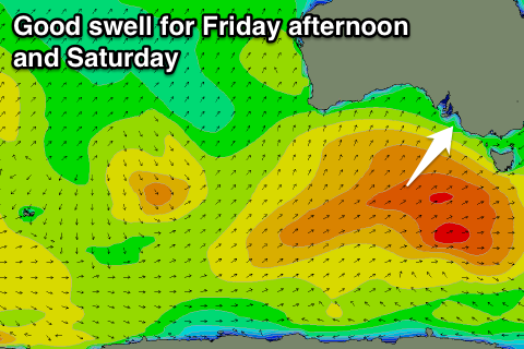 A strong polar front is forecast to develop tomorrow well south of WA, projecting north-east towards us through our south-western swell window while weakening. As the system weakens though, a secondary broad strong front is due to fire up on top of an already active sea state, helping to produce a larger groundswell event for Friday.
Middleton is due to to build to a good 3-5ft through the afternoon Friday with 6ft sets at Waits and Parsons. The swell should hold a similar size into Saturday morning, but another pulse of reinforcing SW swell is due into the afternoon from a broad but weak trailing front pushing under is Friday.
Only a slight drop in size is due into the afternoon and more so through Sunday from 3ft+ at Middleton and 5ft around Waits and Parsons.
Unfortunately winds will be an issue, with a slight chance for an early W'ly before the swell dawn Friday but more so fresh from the SW all day. Only light S/SE winds are due Saturday creating workable conditions, with fresher S/SE winds Sunday.
Mid Coast: Tomorrow's and Wednesday's swell look only to be in the 0.5-1ft range, more in that upper 1ft range later tomorrow and early Wednesday.
Friday afternoon's and Saturday's pulses of swell should provide better 1-2ft waves across the Mid Coast, more 2ft on the favourable parts of the tide.
Longer term we've got another good pulse of long-period S/SW groundswell due Monday from a tight and intense polar low, but more on this Wednesday.