Mid Coast the go Tuesday, South Coast Thursday and Sunday

South Australian Forecast (issued Monday 15th February)
Best Days: Mid Coast Tuesday and early Wednesday, keen surfers down South Wednesday morning but more so Thursday morning and then Sunday morning
Recap
Fun clean start to the weekend in protected locations, best out at Waits before an onshore change moved in mid-morning. The Mid was a tiny and bumpy 0.5ft.
Sunday morning was clean again down South with an early W/NW breeze but the swell smaller and only for keen surfers. The onshore kicked in earlier and created poor conditions as a new S/SW groundswell filled in.
The Mid offered a touch more size to 0.5-1ft before kicking into the afternoon with a new SW groundswell.
This SW groundswell has peaked today with good and workable 2ft sets across the Mid, bigger down South to a good 4ft with an unexpected morning offshore again, which has since swung back to the SW.
This week (Feb 16 - 19)
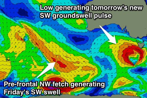 South Coast: Tomorrow should continue to provide plenty of size with a new reinforcing SW groundswell being upgraded since Friday. This is the result of the relatively weak front that was expected to produce it, instead forming into a stronger mid-latitude low, aiming a better fetch of W/SW gales through our swell window, over an active sea state.
A strong pulse of SW groundswell should result, filling in tomorrow and reaching 3-5ft across Middleton with 4-6ft sets at Waits and Parsons, but also with a poor onshore S'ly wind as a ridge of high pressure moves in from the west.
The swell should ease through Wednesday as winds improve and tend lighter E/SE to E through the morning, but conditions will still be all over the place.
Thursday will be the morning to surf with easing amounts of S'ly swell from 2-3ft at Middleton and 3ft+ at Waits and Parsons with a light morning E/NE breeze ahead of afternoon sea breezes.
Into Friday a small pulse of SW groundswell is due from a vast and strong pre-frontal fetch of NW gales south-west of WA. While not ideally aligned we should still see some decent radial spread from this fetch, arriving later Thursday and peaking Friday morning to 2-3ft across Middleton and 4ft at Waits and Parsons.
Unfortunately SE winds are due to kick back in again Friday creating poor conditions.
Mid Coast: Today's good pulse of SW groundswell to 2ft on the sets should persist tomorrow with the new SW swell, best on the favourable parts of the tide.
Morning S/SE winds are due to persist into the afternoon while strengthening.
We should see the swell fade through Wednesday from 1-1.5ft or so, even tinier into Thursday, with Friday's SW swell not due to budge above 0.5-1ft.
This weekend onwards (Feb 20 onwards)
South Coast: A new SW groundswell pulse is due Saturday morning from a small but intense low forming south of WA along the polar shelf and projecting east-northeast towards Tassie through the middle to end of the week.
The size should be similar to Friday's pulse but with fresh to strong SE winds spoiling conditions again. Sunday should be much better but smaller with fading 2ft sets at Middleton and 3ft waves at Waits under morning NE winds.
Mid Coast: Saturday's SW swell should provide some tiny 1ft peelers for beginners, fading back through Sunday.
Longer term there's nothing too major on the cards, but check back here Wednesday for an update on this.