Great down South tomorrow and Wednesday morning

South Australian Forecast (issued Monday 23rd November)
Best Days: South Coast Tuesday and Wednesday morning, Mid Coast early Wednesday, Thursday and Friday morning for keen surfers, South Coast Saturday and Sunday mornings
Recap
Poor small weak onshore waves across the South Coast Saturday, while Sunday was similar through the morning ahead of a strong kick in new S/SW groundswell later in the day, as onshore winds persisted.
The Mid Coast saw fun clean 1-2ft waves Saturday morning, while Sunday was a touch smaller but still offering similar sized 1-2ft sets on the favourable parts of the tide.
Today the S/SW swell was still strong across the South Coast with 3-5ft sets at Middleton but with a persistent onshore SW wind. The Mid Coast was bumpy and tiny with the southerly swell direction.
This week (Nov 24 - 27)
South Coast: Late yesterday's and today's S/SW groundswell is the first of many to come over the coming week across the state.
This afternoon and tomorrow morning a secondary strong pulse of S/SW groundswell is due, produced on the tail of the frontal progression generating our current swell.
We should see Middleton hanging in the 3-5ft range this evening and tomorrow morning.
Much better conditions are due with light offshore N/NW winds with only light to moderate afternoon sea breezes.
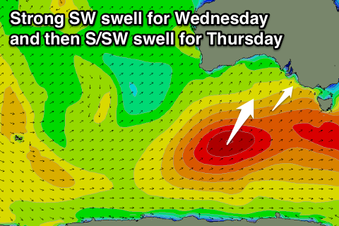 Into Wednesday morning a new pulse of SW groundswell is due from a vigorous frontal system that's currently pushing up from the south of WA towards Victoria. We should see the surf come in at 3-5ft across Middleton again with 6ft+ sets at Waits and Parsons under fresh N/NW offshores ahead of a gusty SW change into the afternoon.
Unfortunately this change will linger into Thursday from the S/SW with another large and strong increase in S/SW swell due. The source of this swell will be a slightly weaker but very favourably aligned polar front being projected north-northeast towards us from tomorrow through Thursday.
The swell should build strongly later Thursday and reach 5-6ft across Middleton on dark, with 6-8ft sets at Waits and offshore reefs, easing back slowly through Friday. Friday morning looks the best of it with winds likely to tend variable creating good workable options around the Chiton Rocks area.
Mid Coast: This afternoon's and tomorrow's S/SW groundswell isn't likely to push above 1ft, but the better SW pulse Wednesday morning should see 1ft to occasionally 2ft sets on the favourable parts of the tide but with early N'ly tending N/NW and then SW winds.
Into Thursday we should see better 2ft waves across the Mid but with that S/SW breeze. Friday will then see the swell easing from 1-1.5ft or so with morning variable breezes.
This weekend onwards (Nov 28 onwards)
South Coast: Good clean conditions are due each morning across the South Coast with easing levels of S/SW swell. Middleton should still offer 3ft+ sets Saturday morning with 4-5ft waves at Waits and Parsons under variable winds through the morning, fading further through Sunday under as variable breezes develop again.
Mid Coast: Nothing of note over the weekend with good conditions but fading surf from 1ft Saturday.
Longer term we should see some new swell early-mid next week, but more on this Monday.