Poor run for the South Coast, Mid Coast will have options to end the week

South Australian Forecast (issued Wednesday 18th November)
Best Days: No good days down South until Tuesday, Mid Coast Friday and Saturday
Recap
Clean but tiny surf yesterday down South only really suitable to exposed breaks while today was even smaller and only for keen desperate surfers. The Mid's been tiny to flat but clean and glassy, great for a swim or fish.
This week and next week (Nov 19 - 27)
South Coast: No change to the swell situation tomorrow with early light W/NW winds and tiny waves, ahead of S/SE sea breezes.
Friday will be even smaller and winds look funky and variable all day before increasing from the W/SW late.
A new kick in W/SW swell should be seen through the afternoon across the South Coast, but the Mid will be a better bet of this.
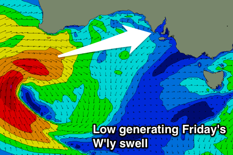 This groundswell which is due to peak overnight has been upgraded a little with the mid-latitude low generating it right off south-west WA this moment, due to produce a better, stronger and more prolonged fetch of W/NW gales through our swell window.
A kick in size to 2ft is expected across the Middleton stretch Friday afternoon with 3ft+ sets at Waits and Parsons, easing from a similar size Sunday with terrible winds, fresh from the S'th along with a junky S'ly windswell.
Sunday will then see the swell bottom out temporarily through the morning with lingering but light S/SW breezes.
Into the afternoon though a strong and powerful S/SW groundswell is due to fill in, peaking Monday morning. This and follow up swells through all of next week will be related to two successive nodes of the Long Wave Trough pushing through our region over the coming period, the second node being more pronounced.
The first node will steer a vigorous polar frontal progression from the south-east Indian Ocean up towards Tassie over the coming days and weekend, through our southern swell window.
The swell should kick later in the day Sunday but with increasing SW winds, peaking early Monday to 4-5ft at Middleton and 6ft+ at Waits and Parsons but along with S/SW winds.
Tuesday looks better as the swell eases slowly and winds tend back to the W/NW, but we'll confirm this on Friday.
The secondary more pronounced node of the LWT will project a series of weaker polar fronts right up into us and Victoria, generating plenty more S/SW swell for the middle to end of the week, but with persistent and poor onshore winds.
Mid Coast: Tiny to flat conditions will continue tomorrow, but Friday's W'ly swell should kick strongly through the day and reach an easy 2ft, backing off to 1-2ft on Saturday with those better S/SE winds.
Late Sunday and Monday's S/SW groundswell should provide tiny waves but only to 1ft or so and with early S/SE winds likely.
The secondary energy into the second half of next week looks a little better, but we'll review this again Friday.