Fun weekend with a strong 'bombing low' swell Monday

South Australian Forecast (issued Wednesday 4th November)
Best Days: Saturday morning and Sunday, Monday, Wednesday on the Mid
Recap
Easing 1ft sets across the Mid Coast after a little kick in swell Monday afternoon, while the South Coast was average with a good pulse of new S/SW groundswell but with strong E'ly winds. Protected spots were the pick for keen surfers.
Today a mix of SE windswell and S/SW groundswell have kept the surf up around a peaky 3ft or so with winds shifting from the NE through to the NW this afternoon. The Mid was clean early but tiny.
This week and weekend (Nov 5 - 8)
South Coast: Early W/NW winds are due across the South Coast tomorrow ahead of a gusty S/SW change late morning/midday. There isn't expected to be any major swell with a leftover mix of S'ly and SW swells to 2ft at Middleton and 2ft+ at Waits and Parsons.
A good mix of strong SW groundswells will fill in Friday but along with fresh but easing onshore S/SW winds. The size of the closer-range SW groundswell has been upgraded a touch with the low generating it being stronger than forecast on Monday.
The Middleton stretch should build to 3-4ft, with 5ft sets at Waits and Parsons, peaking through the evening and then easing back from 3ft and 4-5ft respectively Saturday morning, smaller into Sunday.
Winds will be much better over the weekend with a N/NE offshore Saturday morning ahead of S/SE sea breezes and then N/NE tending variable winds on Sunday.
Mid Coast: The Mid will remain tiny to flat until Friday with we should see 1ft sets into the afternoon, fading through Saturday from 0.5-1ft.
Next week onwards (Nov 9 onwards)
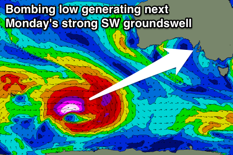
South Coast: The strong SW groundswell due Monday across the state is still on track with a surface low drifting off of South Africa now currently being absorbed into the westerly storm track as it tracks south-east.
This will result in the low re-intensifying, with it 'bombing' as it drops well over 24hPa in a 24 hour period from 980hPa down to 936hPa.
As the low 'bombs' a pre-frontal fetch of severe-gale NW winds will then be closely followed by a stronger storm to hurricane-force fetch of W/SW winds to the south-west of WA.
The low will weaken south of WA, leaving a strong but inconsistent SW groundswell to travel towards us.
The 22s forerunners are due to arrive later Sunday evening across Cape du Couedic, with the bulk of the swell filling in Monday and peaking through the afternoon. Middleton should build to a strong but inconsistent 3-4ft+ with 6ft sets at Waits and Parsons.
Winds look favourable as the swell builds and offshore from the N/NE but we may see the head of a S/SE change moving in through the afternoon, we'll review this Friday.
Mid Coast: The inconsistent SW groundswell is due to build to an inconsistent 1ft+ through Monday afternoon, with the follow up W/SW energy keeping similar sets hitting Tuesday with a better 1-1.5ft pulse likely Wednesday with those favourable SE winds.