Nothing too special to end the week, fun weekend

South Australian Forecast (issued Wednesday 21st October)
Best Days: Keen surfers with lots of foam across the Mid tomorrow and Friday, keen surfers
Recap
Fun clean 2ft waves across the South Coast yesterday for most of the day, with 1-1.5ft waves across the Mid Coast which deteriorated through the day.
Today an onshore change has brought poor conditions to the South Coast with weak levels of building windswell, while a fun W/SW swell is breaking across the Mid to 2ft with workable onshore winds.
This week and weekend (Oct 22 – 25)
South Coast: Today's onshore change is kicking up a building and junky S'ly windswell that's expected to ease back through tomorrow as the trough responsible continues moving east.
This will see easing and junky 2-3ft waves across all locations with poor S/SE winds.
A new S/SW groundswell due into the afternoon is still on track, with Middleton due to reach 3-4ft later in the day with 4-5ft sets at Waits and Parsons, easing from a similar size Friday morning.
Conditions should improve Friday but remain peaky with a moderate to fresh E/NE'ly through the morning ahead of fresh to strong S/SE sea breezes.
Saturday will be much cleaner as the swell eases from 3ft across the Middleton stretch and 4-5ft at Waits and Parsons with N/NE offshore ahead of weak sea breezes.
A small fun reinforcing S/SW groundswell is due Sunday from a deepening polar low late in our swell window, south-west of Victoria tomorrow and Friday.
This should keep good 2ft+ sets hitting Middleton with 3ft+ waves at Waits and Parsons.
Winds will be best early and fresh and gusty from the N/NE, tending N/NW through the morning ahead of an onshore change at some stage through the afternoon (we'll have a better idea on the timing Friday).
Mid Coast: Today's W/SW swell and S/SW windswell are due to fade into today from 1-1.5ft but conditions will be much cleaner with those S/SE breezes.
The S/SW groundswell due later in the day and Friday should keep infrequent 1-1.5ft sets hitting the coast before fading into the weekend.
Next week onwards (Oct 26 onwards)
South Coast: Sunday's change will create poor conditions into Monday with strengthening S/SE winds and a building S/SE windswell.
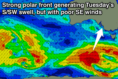 A stronger S/SW groundswell due for Tuesday (discussed on Monday) is still on track, but so are the poor SE winds with it.
This groundswell will be generated by a strong polar frontal progression firing up under the country through our southern swell window, with a pre-frontal fetch of W/NW gales being worked over by a stronger post-frontal fetch of W/SW gales.
A moderate to large S/SW groundswell will result, filling in through Tuesday to a solid 3-5ft across Middleton and 4-6ft at Waits but with SE winds.
Unfortunately SE winds are likely to remain entrenched across our coast for all of next week as an inland surface trough stalls across the south-east of the country. This will create poor conditions, even with a couple of fun groundswells on the cards.
Mid Coast: The Mid will struggle to see any major size from the S/SW swell Tuesday above 0.5-1ft with tiny to flat surf the rest of the week.
Comments
How's these lines at the Mid! If only it were four feet bigger...