Average week, best Thursday morning, better swell from Sunday

South Australian Forecast (issued Monday 12th October)
Best Days: Thursday morning, Sunday morning
Recap
Fun waves early Saturday with clean 2-3ft sets across Middleton and more size out at Waits, but a funky trough brought some tricky winds which varied considerably during the day. The Mid Coast saw tiny 0.5-1ft surf which deteriorated through the day.
Into Sunday the swell was smaller and winds funky again, variable early creating lumpy conditions before increasing from the S/SW.
Today small bumpy and onshore waves were seen down South with the Mid offering cleaner but tiny 0.5-1ft sets for beginners.
This week (Oct 13 – 16)
Give tomorrow a miss, as today's small kick in swell is due to ease under less than favourable E/SE winds across the South Coast.
Wednesday will be much cleaner with N/NE offshores ahead of a shallow sea breeze, but the swell small to tiny. Middleton is only due to offer 1ft+ waves with the odd 2ft set at Waits and Parsons.
Thursday morning will be a better day to surf, although offshore winds are due to be stiffer with a fresh to strong N/NE tending N/NW breeze ahead of a shallow afternoon change. A new inconsistent W/SW swell is due, generated in our far swell window the last couple of days by a weakening pre-frontal fetch of W/NW gales.
This should provide small 2ft waves across Middleton with 3ft+ sets at Waits and Parsons while the Mid should also offer tiny but bumpy 0.5-1ft waves most of the day.
Friday looks average, with lingering SW winds in the wake of Thursday's onshore change, and the models are over-forecasting the size a little with a mix of very long-range W/SW groundswell from under South Africa combining with some small closer-range energy. In any case it looks like a good lay day.
This weekend onwards (Oct 17 onwards)
 Saturday is looking to remain dicey with light lingering onshore winds and easing levels of swell from 2ft at Middleton and 3ft+ at Waits and Parsons.
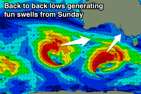
Of greater significance is some better swell activity due from Sunday across the state as a couple of strong and favourably tracking lows push under the country under the influence of the Long Wave Trough.
The first low is forecast to produce a fetch of gale to severe-gale W/SW winds through our south-western swell window on Thursday and Friday, producing a good SW groundswell pulse that may be seen late Saturday, peaking Sunday morning.
Middleton should see good 3-4ft sets with 5-6ft waves out at Waits and Parsons, and 1-1.5ft waves on the Mid. Variable winds are likely through the morning from the E/SE, creating workable conditions across both coasts.
A secondary W/SW pulse is then due later Monday/Tuesday and this should produce better 2ft sets on the Mid, but we'll review this again on Wednesday.