Excellent period ahead for South Oz

South Australian Surf Forecast by Ben Matson (issued Monday 28th September)
Best Days: Wed: Easing S'ly swell with early light E/NE winds. Sat/Sun/Mon: small fun waves on the Mid, generally clean. Very small at Victor due to the W'ly swell direction but generally clean. Tues PM thru' end of next week and into the weekend: series of strong, long period groundswells with plenty of fun day across the Mid; Victor looking towards the end of the week and the weekend as the swell direction swings more SW.
Recap: Small but fun clean waves at Victor over the weekend with offshore winds. Tiny surf along the Mid Coast. A small new swell has provided a marginal bump across the Mid this morning (0.5-1ft) and onshore winds are ruining conditions down south.
This week (Sep 29 - Oct 2)
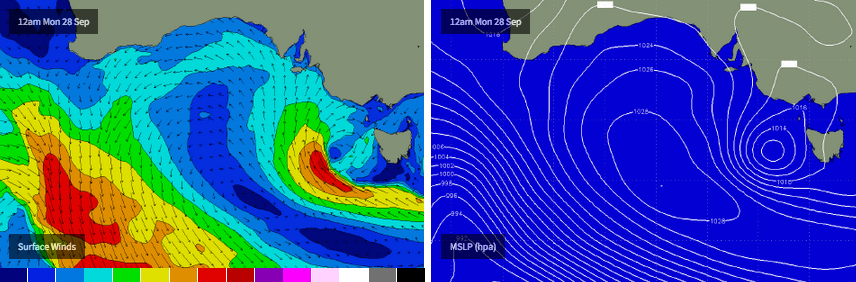
Gotta love a complex forecast chart.
The CdC buoy shows signs of a small long range SW swell arriving earlier this morning: not the size - most of the Hsig increase is locally generated - but you can see peak periods bumped up to 15 seconds around dawn. This wasn’t meant to produce much of an increase anyway, so today’s surf is inline with expectations. This particular swell will ease slowly through Tuesday with moderate southerly winds easing about the coast.
The synoptic chart presently has a low forming west of Tasmania (see chart below). This low is unusual, in that it’s slow moving and also has the strongest pressure gradient on its south-western flank, which is aimed up into South Australia.
Unfortunately, the low is small in size and won’t last long but it will generate a fun S/SE swell for the South Coast that’ll build through Tuesday (3ft+ sets by the afternoon) before easing Wednesday.
It’s a shame local winds aren’t looking favourable as these swells often produce a much more even spread of size across the South Coast, compared to SW swells. But, it’ll be worth checking out though if you have some time: Wednesday morning may see some leftover sets in the 2-3ft range and winds should be light E/NE by this time with a few wobbles on top from the previous days’ onshores.
Obviously, it goes without saying that southerly swells won’t produce anything across the Mid due to the shadowing effects of Kangaroo Island. However there’ll probably be some small residual teaser lines on offer both days, as is often the case.
The second half of the week looks interesting but ultimately small. We’ve got a complex blocking pattern across our swell window, dominated by an amplifying Long Wave Trough across the Southern Indian Ocean. This is a slow moving system and will eventually generate some good surf for the state, but the second half of this week looks a little lacklustre.
Thursday does show some interesting activity on the swell period charts, with a defined swell front expected to push later Wednesday. However, this appears to have been generated by a pre-frontal NW fetch in the Indian Ocean over the last day or so (which is surprisingly not that far off-axis from the South Coast's swell window) - but the large travel distance and modest fetch means that the associated swell size isn’t very big.
As such I’m expecting small surf across the Victor stretch on Thursday, with light variable winds. I can’t see there being anything of note along the Mid Coast either.
Friday has freshening N’ly winds, and another small swell expected to glance the region (according to the period charts again), once again originating from a strong NW flow down the eastern flank of the Long Wave Trough in the Southern Indian Ocean.
This system looks potentially promising for the Victorian coast but I’m a little worried that its source will reach maturity just as it passes through the eastern periphery of the South Coast’s swell window. So, for now I’m going to maintain small waves down south on Friday - maybe a slight increase in the frequency of the 2ft’ers - but it’ll be clean with light offshore winds. Again, no great surf is expected along the Mid Coast.
This weekend (Oct 3 - 4)
The period charts are awash with reds and purples for the weekend, which ordinarily suggests good (long period) swells - however we have to be careful this weekend as the direction will play a big part in how much size we see at various locales.
All of this energy is originating form the eastern flank of the Long Wave Trough in the Indian Ocean; in fact the predominant fetch is NW thru’ W/NW in direction, meaning the resulting swells through the Bight will have a lot of west in their direction. This is a good thing for the Mid Coast, but not good at all for Victor.
The upside for the South Coast is that winds are expected to generally be offshore. Model guidance does suggest a weak trough on Sunday (leading to variable winds) but they’ll swing N’ly again on Monday.
Getting the size right for the Mid Coast will be hard as these swells will have been generated a very long distance away, and the bulk of the fetch is aimed up into Indonesia (good time to book a last minute flight!).
However there’s a reasonable westerly fetch on the northern flank of the LWT that’ll drive these swells through our window, and I think it’s reasonable to expect inconsistent but well defined sets somewhere in the 1-2ft range both Saturday and Sunday - likely biggest in the afternoons with some tidal assistance providing occasional 2ft+ bombs at the reefs. But the waits between sets will be considerable.
Down south, I doubt we’ll see much more than a foot or so at Middleton all weekend (all thanks to the swell direction) so the best options will be at the exposed beaches where 2ft+ sets are more likely.
Next week (Oct 5 onwards)
The last day of the Long Weekend looks like it’ll maintain Sunday’s size before easing throughout the day. So, expect small residual (and tidally affected) waves across the Mid and small clean surf down south.
Beyond this, we have a strong series of W’ly tending W/SW then eventually SW swells as the Long Wave Trough finally moves slowly eastwards through our swell window. And it’s looking good for the Mid Coast with some quality groundswell on the way.
At this stage, the first (W’ly swell is due to arrive later Tuesday ahead of a peak on Wednesday (2-3ft surf in the gulf looks quite likely), with the followup W/SW and SW swells padding out the back half of the week and the following weekend that’ll be better suited for some solid size at Victor (whilst maintaining small clean waves along the Mid Coast).
All in all, next week is certainly shaping up to deliver an extended period of very good waves right across the state. More on this in Wednesday’s update.
Comments
Hi Ben,
With this swell to hit indo will it be getting into elliston (cactus)? And how big do you think it will get there?
Cheers
Differernt swells from the same broadscale weather system. The swell heading up to Indo is off the backhalf of the Long Wave Trough (the broad fetch of SW gales), while the swell we'll see in South Oz will be from the northern flank (smaller fetch of W'ly winds). The direction will be more west than usual but quite sizeable, depending on exposure (not everywhere is completely open to all swell directions). Size? Somewhere north of 6ft at exposed spots, possibly bigger. Our model forecasts for Cactus (6ft), Streaky (6ft+) and Elliston (6ft+) all seem pretty spot on to me.
Deceptively attractive still from the Mid Coast this morning (one of our random surfcam stills taken every five minutes).
Tabby might want to know that cactus is 400 km from elliston ?