Fun weekend, best Sunday

South Australian Forecast (issued Friday 17th July)
Best Days: Saturday mid-morning onwards, Sunday, Monday morning, Wednesday, Thursday
Recap
Fun easing 1ft to occasionally 2ft waves across the Mid Coast yesterday with a cross-offshore wind, while the South Coast was a total mess with the S/SE wind. This morning the Mid was much tinier and cleanish, while the South Coast continued to offer plenty of swell but poor, junky conditions.
This weekend and next week (Jul 18 - 24)
Saturday will be a lot better than today across the South Coast but Sunday is the pick of the weekend.
A mix of strong new S/SW groundswells are due to fill in tomorrow, with good 3-5ft sets due across Middleton with 5-6ft sets at Waits and Parsons under a moderate E/NE breeze.
This will create improving conditions through the morning, but the surf will still be real lumpy/peaky and wobbly. We may even see winds tend more NE towards midday, creating the cleanest conditions before swinging back to the E/SE-SE through the afternoon at some stage. The Mid will be clean but tiny.
 Sunday looks great, with straight offshore N'ly winds, tending variable into the afternoon with a dropping swell from 3-4ft at Middleton, and 4-5ft at Waits, back to 2-3ft and 3-4ft respectively through the late afternoon.
Monday will be smaller again and best at exposed locations with a fresh to strong N'ly tending N/NW breeze.
A slight kick in inconsistent SW groundswell is due Tuesday morning, but to no major size with inconsistent 1-2ft sets at Middleton and 2ft+ waves at Waits under a strong but easing N/NW wind. With this in mind, it's probably not worth a drive from Adelaide.
At the same time, with these strong N/NW winds a small NW windswell will develop on the Mid Coast Monday, reaching 1-1.5ft later Monday and coming in around 2ft Tuesday before easing Wednesday as winds relax.
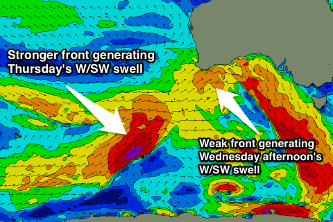
On the South Coast, Wednesday will remain clean with a small increase in W/SW swell, reaching 2-3ft at Middleton into the afternoon and 3-4ft at Waits and Parsons. The Mid Coast should see this same swell build to 1-2ft into the afternoon.
A better swell is due Thursday morning, generated by a strong and favourably tracking polar front from the south-west of WA, up under the Bight early next week.
This should provide good 3-4ft waves at Middleton and 5ft+ sets at Waits and Parsons with 2ft sets on the Mid under favourable N/NE tending variable winds.
A drop is then due into Friday as winds swing back to the NW, but we'll look at this closer Monday. Have a great weekend!