Stormy weekend ahead, windows of better conditions next week

South Australian Forecast (issued Friday 10th July)
Best Days: Saturday protected spots down South, Saturday and Sunday keen surfers on the Mid, Monday morning protected spots down South, Tuesday down South, possibly Wednesday down South
Recap
Fun day of surf across both coasts yesterday with a clean building swell down South with offshore tending variable winds, and glassy good waves on the Mid into the afternoon as winds also tended variable.
Today the swell eased back to a small 2ft across Middleton, with Waits the pick before winds strengthened from the NW. The Mid Coast held around 1-2ft with early workable winds, but these have since shifted onshore from the NW.
This weekend and next week (Jul 11 – Jul 17)
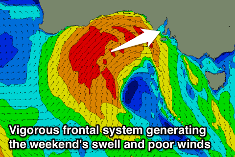 We've got a cold and stormy weekend on the way with a vigorous two-pronged cold front due to push in and across us this evening and through the weekend.
Currently a fetch of SW gales are being aimed through our western swell window, pushing east through the Bight, generate a moderate to large W/SW groundswell for tomorrow, peaking into the afternoon.
This front will push into us this evening, with fresh to strong W/NW winds due ahead of a stronger S/SW change mid-late afternoon.
With this we should see the Mid Coast offer semi-stormy 3ft waves, pulsing later with the change.
A drop from a semi-stormy 3ft is then due into Sunday with strong but easing SW tending S/SW winds.
The South Coast should see a mix of SW groundswell and building W/SW swell tomorrow, with protected locations fairing the best. Middleton is expected to build from 3ft during the morning to 3-5ft later in the day, with 4-5ft sets at Waits, pulsing to 6ft late (but with that onshore change).
Sunday will see larger S/SW swell in the mix from a strong fetch of S/SW winds pushing into us Saturday, coming in at a stormy 6ft+ across most breaks through the morning, easing into the afternoon.
Come Monday the swell should continue to ease, dropping from 2ft on the Mid and 4-5ft across most locations down South with a fresh SW'ly. The South Coast may see an early W'ly around Victor, with protected locations fairing the best.
From Tuesday the models diverge on a secondary cut-off low pushing in from the west.
The American version has this low stalling and sitting to our west in the Bight resulting in offshore winds across the South Coast both Tuesday and Wednesday. The European model on the other hand has the system pushing east towards Victoria resulting in W/NW winds Tuesday and developing onshore SW winds Wednesday.
In any case, a good new pulse of SW groundswell is due Tuesday, generated by a pre-frontal fetch of W/NW gales to the south-west of Western Australia today and tomorrow, followed by stronger polar trailing W/SW winds.
This should come in at 3-4ft across Middleton, with 5ft+ sets at Waits and Parsons under likely W/NW winds.
Wednesday is too hard to pick at this stage with the model divergence so you'll have to check back Monday for an update on how the rest of next week looks. Have a great weekend!